
Download this article as a PDF
Introduction
1. This paper responds to the matters and issues raised through responses on proposed Main Modifications to the Purbeck Local Plan (2018-2034). The consultation on proposed Main Modifications was held between November 2020 and January 2021. The representations received during the consultation are published on the council’s website along with a consultation response document.
2. The council found merit in the representations relating to proposed Main Modifications to ‘Policy V2: Green Belt’ and its supporting text (proposed Main Modifications 6 and 7) and to ‘Policy I5: Morden Park strategic suitable alternative natural green space (SANG) and holiday park’ and its supporting text (proposed Main Modifications 76 and 77). In response to these matters the council has invited the Planning Inspector examining the local plan to consider Further Proposed Main Modifications to these policies which would delete reference to release of Green Belt at Morden for a holiday park.
3. The council and Charborough Estate intended that the holiday park would act as enabling development to support delivery of the strategic SANG. The council continues to support delivery of a strategic SANG at Morden independently of the proposed holiday park. Charborough Estate have confirmed that the land where the SANG is identified is not available for this use without the enabling development. The council will continue to investigate the opportunities to deliver the SANG (and therefore seeks to retain Policy I5 in the emerging local plan), but given the uncertainty around its delivery we have sought to investigate interim measures to mitigate the impacts of residential development on Dorset Heaths Special Area of Conservation (SAC), Dorset Heathland Special Protection Area and Ramsar and Dorset Heaths (Purbeck & Wareham) & Studland Dunes SAC (here after collectively referred to as Dorset heaths habitat sites).
4. This interim strategy in this document specifically relates to Dorset heaths habitat sites. As part of submitting the local plan for examination, and in the course of the hearing sessions, we have submitted detailed evidence and prepared planning policies relating to other habitat site issues in Purbeck including: Habitat Regulation Assessments, Policies E7 and E9 and supplementary planning documents [1]. This evidence outlines our approach to mitigating the impacts on these habitat sites (including Poole Harbour and New Forest Heaths). Matters and issues relating to this approach to mitigation have been considered at length during the examination and will not be affected by the Further Proposed Main Modifications. For these reasons this paper has a limited scope around considering the implications on Dorset heaths habitat sites.
5. This paper:
a) summarises the matters and issues raised in representation on proposed Main Modifications to Policies V2 and I5 and provides an explanation of the council’s position on these matters and issues;
b) re-examines the evidence around the need for heathland infrastructure projects to mitigate the impacts of residential development on Dorset Heathland Special Protection Areas, Dorset Heathland Ramsar and Dorset Heaths SAC in Purbeck;
c} considers housing supply, housing delivery and delivery of heathland infrastructure projects in adopted local plans, the emerging Purbeck Local Plan (2018-2034) and neighbouring areas;
d) proposes an interim approach to habitat site mitigation for Dorset heaths habitat sites in Purbeck; and
e) outlines Further Proposed Main Modifications to Policies V2 and I5 (the council has outlined Consequential Further Proposed Main Modifications that are linked to the proposed changes to Policies V2 and I5 – for the most part these include updating the text or policy of the plan which cross references an earlier draft of either Policy V2 or I5).
Matters and issues raised through consultation representation on proposed Main Modifications
6. Following receipt of a Post Hearing Note (March 2020) from the Planning Inspector examining the Purbeck Local Plan, the council opened a consultation on series of proposed Main Modifications (MMCD1). The consultation took place between November 2020 and January 2021. An overview of the consultation process and summary of the matters and issues raised is presented in the consultation response document.
7. Except for representations relating to Policies V2 and I5 (and their supporting text), the council is satisfied that the proposed Main Modifications presented in MMCD1 are sound and legally compliant.
8. The proposed Main Modifications relating to V2: Green Belt and I5: Morden Park strategic suitable alternative natural green space (SANG) and holiday park which were subject to consultation are presented in Appendix 1 of this paper. For the purposes of this paper the council has summarised the content of the matters and issues raised through consultation on these policies below for ease of reference and then indicated the key issue that the representation relates to. Copies of the representations in full are presented on the council’s website.
9. Representations on policies V2 and I5 have raised the following key issues:
a) the council has not considered reasonable alternatives for strategic SANG. (Key Issue: the council’s approach to release of Green Belt and delivery of a holiday park at Morden have not been fully evidenced and justified);
b) it not being appropriate to take account of the delivery of strategic SANG/delivery of biodiversity net gain (holiday park)/positive management for habitats (holiday park), as exceptional circumstances (Key Issue: the council’s approach to release of Green Belt and delivery of a holiday park at Morden have not been fully evidenced and justified);
c) the council has not considered alternative ways of funding SANG or evidenced/justified the joint approach to funding the SANG (Key Issue: the council’s approach to release of Green Belt and delivery of a holiday park at Morden have not been fully evidenced and justified);
d) the quantity of land released from the Green Belt for holiday homes is not proportionate with the size of the strategic SANG (Key Issue: the council’s approach to release of Green Belt and delivery of a holiday park at Morden have not been fully evidenced and justified);
e) the proposed SANG at Morden will not provide strategic mitigation to development in the north of Purbeck (Key issue: the council’s local plan policies and strategy for habitat site mitigation do not meet the requirements of The Conservation of Habitats and Species Regulations 2017);
f) inadequate screening for likely significant effects on Special Protection Area, Special Area of Conservation and Ramsar (Key issue: the council’s local plan policies and strategy for habitat site mitigation do not meet the requirements of The Conservation of Habitats and Species Regulations 2017);
g) tourist accommodation / SANG / other uses are positioned within 400 metres of Dorset heath and therefore inconsistent with other policies in the local plan (Policy E8) (Key issue: the council’s local plan policies and strategy for habitat site mitigation do not meet the requirements of The Conservation of Habitats and Species Regulations 2017);
h) the HRA is unlawful and does not meet the requirements of the Conservation of Habitats and Species Regulations 2017 and related Habitats Directive (Key issue: the council’s local plan policies and strategy for habitat site mitigation do not meet the requirements of The Conservation of Habitats and Species Regulations 2017); and
i) there are no adequate safeguards around delivery of the SANG through Policy I5 if land for the holiday park is released from the Green Belt (Key issue: the council’s local plan policy is not effective);
10. After long consideration (including review of earlier representations, Memorandum of Understanding relating to Morden Park, national planning policy and the evidence that the council presented on this matter in SD93) the council is satisfied that there is merit to some (summarised in paragraphs a) to d)) of the matters raised through representation. The next sections of this paper summarise the matters and issues which the council considers have merit.
Key Issue: the council's approach to release of Green Belt and delivery of a holiday park at Morden has not been fully evidenced and justified
11. To assist in the discussion in this paper the council has elaborated on the assertions in the representation and presented in paragraphs 9 a) to d). The main points are
a) the council has failed to fully examine alternative options for a strategic SANG in the north of Purbeck and for these reasons the policy relating to the release of Green Belt is inconsistent with national planning policy (paragraphs 136 and 137 of the NPPF (National Planning Policy Framework));
b) that the council has not fully or properly explored the potential to independently acquire land for a strategic SANG here or elsewhere using contributions collected from planning obligation / Community Infrastructure Levy (CIL) receipts. Nor has the council considered compulsory purchase of the land to deliver a strategic SANG at Morden or elsewhere. Nor has the council fully or properly explored through viability assessment that level of Green Belt release / number of proposed holiday homes is justified. And for these reasons the policies for Green Belt release and delivery of the holiday park are inconsistent with national planning policy (paragraphs 136 and 137 of the NPPF); and
c) the amount of Green Belt land released to allow delivery of the SANG is disproportionate. And for these reasons the policies for Green Belt release and delivery of the holiday park are inconsistent with national planning policy (paragraphs 136 and 137 of the NPPF).
12. Examination document SD93: Mitigation Strategy Green Bel was published after the first examination hearings in public (the first hearing session was held in July). Paragraphs 36 to 40 of SD93 relate to the council’s consideration of alternative strategic SANG for northern Purbeck.
13. Alternative options for development (comprising options for new homes with accompanying SANG) were presented in the Partial Review Options Consultation (2016). Opportunities were identified as follows: around Lytchett Minster (referred to as Site 2, on pages 27 and 28), between Lytchett Minster and Lytchett Matravers (referred to as Site 14, on pages 54 to 55) and the site at Morden Park (currently referenced as Policy I5 and referred to ‘Morden Country Park’ on pages 87 to 89). All the options considered included an element of enabling development in the form of homes or holiday park. Changes to Green Belt boundaries would be required to support delivery of the enabling development.
14. National planning policy describes the fundamental aims and purposes of Green Belt (paragraphs 137 and 138 of the NPPF 2021) and sets out the process for examining alternative means of meeting an identified need for development (paragraph 141) before a council may conclude that exceptional circumstances exist to change Green Belt boundaries.
15. In this instance the council considers that there is a need for heathland infrastructure projects in Purbeck as part of the measures required to mitigate the impacts from unplanned (including extant minor/major planning permissions, ‘windfall’ and development arising from small sites) residential development [2] on Dorset heaths habitat sites. Paragraph 141 of the NPPF states that consideration of ‘other reasonable options’ for meeting an identified need for development will be assessed through the local plan examination having regard to whether the strategy:
a) makes as much use as possible of suitable brownfield sites and underutilised land;
b) optimises the density of development in line with the policies in chapter 11 of this Framework, including whether policies promote a significant uplift in minimum density standards in town and city centres and other locations well served by public transport; and
c) has been informed by discussions with neighbouring authorities about whether they could accommodate some of the identified need for development, as demonstrated through the statement of common ground.’ (Paragraph 137 of the NPPF).
16. The council evaluated the effectiveness of alternative SANG at Bere Farm and Lytchett Minster in comparison with the proposed SANG at Morden taking guidance from Natural England. Its assessments are presented in SD93 [3]. The council sought to define options using development sites/SANG which were made available at earlier consultation stages of the local plan. All the options which the council considered involved release of Green Belt to allow delivery of homes/holiday homes. In each instance the SANG would also need to mitigate the impacts of enabling development. In most instances the council considers that SANG have the potential to be an appropriate form of development within the Green Belt as their use for recreation can take place while preserving the Green Belt’s openness in a way that is consistent with the purposes listed in paragraph 138 of the NPPF. Use of SANG also has the potential to enhance beneficial use of the Green Belt (for example use of SANG provides an opportunity for public access and recreation) in accordance with paragraph 145 of the NPPF.
17. The council accepts that it did not demonstrate through SD93, that it had fully examined the opportunity to deliver heathland infrastructure projects (including strategic SANG) in locations outside the Green Belt where they would serve a similar function or on sites within the Green Belt without the need for changes to Green Belt boundaries. As part the process of examining alternatives the council did not fully explain its approach to funding the proposed Morden SANG or explore the opportunity to fund (through contributions collected via planning obligations or CIL contributions) heathland infrastructure projects independently of enabling development that required release of Green Belt. As part of this process nor did the council consider making use of compulsory purchase powers to secure delivery of heathland infrastructure projects.
18. The council also accepts that its comparison of alternatives did not include an evaluation of whether land to be released from the Green Belt as enabling development was proportionate with the SANG to be delivered (having regard to both its size and its function as part of the Green Belt).
19. For the reasons outlined above the council accepts that the proposals in Policy I5, involving release of Green Belt for a holiday park (also referenced in proposed Main Modifications to Policy V2), were not justified or consistent with national planning policy.
20. The respondent also asserts that it was not appropriate for the council to take account of delivery of a strategic SANG, net gains in biodiversity or positive environmental land management at the proposed holiday park as ‘exceptional circumstances’ when assessing whether Green Belt release was justified at Morden Park. The council does not accept the respondent’s position on this issue. National planning policy does not define what can be treated as exceptional circumstances. All of the matters which were referenced by the council in its pre-submission Green Belt study (where it considered whether there were exceptional circumstances for Green Belt release, SD56: Green Belt Study) are relevant to planning and the site at Morden. The council specifically referenced the following as exceptional circumstances:
- the site will deliver a strategic SANG; and
- the effects of the holiday park can be partially offset through compensatory improvements.
21. The council has determined the nature and extent of harm to the Green Belt arising from the release and the potential to ameliorate or reduce the harm to Green Belt via compensatory improvements to remaining Green Belt. It considers that it has exercised appropriate discretion, within the parameters set by the NPPF, on what could legitimately amount to exceptional circumstances in this instance.
Key Issue: the council's local plan policies and strategy for habitat site mitigation do not meet the requirements of The Conservation of Habitats and Species Regulations 2017
22. Paragraph 10 e) to h) above summarise the grounds, which the respondents consider, demonstrate that this part of the local plan is not compliant with the habitat regulations.
23. The respondent considers that the proposed SANG at Morden will not be effective. The council considers that the Morden site is a suitable location for a strategic SANG. (Further justification is set out on pages 126 and 127 of the Partial Review Options Consultation Report (2017)).
24. The respondent considers that the council’s screening for likely significant effects on habitat sites is not satisfactory. The council does not accept that its screening of likely significant effects from both the proposed holiday park and SANG is flawed. The council specifically considered whether Policy I5 would give rise to issues of likely significant effects on functionally related habitat, habitat site fragmentation and on mobile species endemic at the habitat site. (It has provided further response on this matter through paragraph 205 of its consultation response document). The council has considered and screened out water availability as a potential pathway for likely significant effects for all elements of the local plan (see page 124 of the Partial Review Options Consultation Report (2017)).
25. The respondent considers that development will be positioned close to habitat sites where other planning policies in the local plan indicate that adverse impacts are unavoidable. The council has specifically considered the relationship between the proposed holiday accommodation and the Dorset heath habitat sites. Following discussion and clarification (provided through the Memorandum of Understanding between the council, Charborough Estate and Natural England) it is satisfied that the chalets could be set back north and east of the lake beyond the 400 metre boundary of the habitat site (this allowed the council to rule out adverse effects, including: noise/light/fire etc.).
26. The council does not accept that its HRA is unlawful, to the contrary it considers its assessments comply with the requirements of the Habitats Regulations.
Key issue: the council's local plan policy is not effective
27. The council understands that the respondent considers that the detailed drafting of Policy I5 does not limit Green Belt release to that necessary to deliver the SANG or impose specific controls on the intensity of development within the holiday park. The respondent considers that for these reasons the policy is not effective or consistent with national planning policy (paragraphs 35 c and 136 to 137 of the NPPF February 2019 (now paragraphs 140 and 141 NPPF July 2021).
28. The supporting text to Policy I5 (proposed Main Modification 76) does refer to an upper limit on the amount of holiday accommodation (of up to 100 units) permitted on the holiday park site [4]. Proposed Main Modification to Policy I5 (MM 77) also states that ‘The holiday park will only be permitted to facilitate the delivery of the SANG. The SANG must be completed and open for use before use of the holiday park begins.’ Through MM 77 the council also specifies criteria for design and management of the SANG and a masterplan. The council accepts that there might be merit in the policy text referring to a limit on the amount of holiday accommodation permitted to ensure the effectiveness of the policy.
29. The proposed Main Modifications which were consulted upon are presented in Appendix 3 – Proposed Main Modifications (November 2020 to January 2021) relating to policies V2: Green Belt and I5: Morden Park strategic suitable alternative natural green space (SANG) and holiday park.
30. The council accepts that the proposed changes to Green Belt boundaries at Morden have not been justified (in accordance with national planning policy). The council has invited the Inspector to consider Further Proposed Main Modifications to policies V2 and I5 to reflect its position on this matter. These modifications are presented in Appendix 5.
31. In brief the Further Proposed Main Modifications comprise:
- Removing reference to changing Green Belt boundaries at Morden from the supporting text relating to Policy V2 (paragraphs 43 to 46 of the local plan) (Further Proposed Main Modification 6);
- Amending the justification for the proposed Main Modification (Further Proposed Main Modification 6);
- Removing reference to the holiday park at Morden Park from Policy V2 (Further Proposed Main Modification 7);
- Removing reference to the holiday park at Morden Park from the supporting text of Policy I5 (paragraphs 256 to 257) (Further Proposed Main Modification 76);
- Amending the justification for the proposed Main Modification (Further Proposed Main Modification 76); and
- Removing reference to the holiday park at Morden Park from Policy I5 (including the requirement to prepare a masterplan for the holiday park) (Further Proposed Main Modification 77).
32. The council also proposes to revise the local plan policies maps (specifically the inset map relating to Morden) to take out reference to the release of Green Belt and the policy area which encompassed the proposed strategic SANG and the land to be released from the Green Belt. The proposed strategic SANG will continue to be identified on the inset policies map.
33. Given the reliance on the proposed Morden SANG to mitigate the impact of residential development on Dorset heaths habitat sites, and the clarification that has now been provided by the Charborough Estate that the land for the SANG will not be made available without the enabling development, the next parts of this paper consider the need of heathland infrastructure projects, delivery of homes/heathland infrastructure projects and outline an interim approach to achieving suitable mitigation for Dorset heath habitat sites.
The need for strategic habitat site mitigation in Purbeck
34. As presented in SD93, a strategic SANG is needed in northern Purbeck to:
a) ‘provide an alternative location specifically for those people visiting Morden Bog SSSI, SPA, SAC and Ramsar which is within the wider Wareham Forest area (visitor data from Sherford Bridge, immediately south of the proposed SANG and north east of Morden Bog indicates that the majority of visitors to the protected Morden Bog access the site along the A35 corridor, Bere Regis in the west and Lytchett Matravers, Corfe Mullen and Poole in the east); and
b} address the additional effects of new housing development expected in this part of the area (including completed and expected windfall development, and allocations from earlier plans).’ (Paragraph 35, SD93).
35. The ‘Habitats Regulation Assessment of the Purbeck Core Strategy, Proposed Changes to the Pre-submission Version, Sept 2011’ identifies several broad locations which would be ideally suited for larger SANG in the context of growth in the five spatial areas [5] identified in the Purbeck Local Plan Part 1 (Paragraph 5.53). These included: in northern Purbeck, near to Wareham and north of Studland. (Paragraph 5.52). Subsequently the council’s latest HRA of all proposed main modifications states that ‘The HRA for PLP 1 identified the need for a SANG in the north of the then Purbeck District, and the need for strategic SANG in this area was confirmed by Natural England at examination. In the HRA report at Options stage, the potential for part of the proposal to come forward as a strategic SANG is discussed, i.e. a SANG that provides capacity for absorbing recreation pressure from other developments in the Purbeck area.’ (Paragraph 5.62).
36. The latest HRA goes onto state:
‘At the local plan level, it can be concluded that it would be possible for a strategic SANG [with reference to the proposed strategic SANG at Morden] to function and in many ways the location is ideal. New facilities here could be linked with management of roadside parking along the B3075 to better manage access across this part of Wareham Forest. Ideally parking locations at Great Ovens and at Sherford Bridge could be closed/reduced in order to push existing use towards the SANG. As such there are some clear positive benefits for the European sites. Potential constraints relate to the chalet accommodation and how these can be made compatible with the SANGs delivery, which need to be developed in more detail at project level HRA.’ (Paragraph 5.66).
37. A summary of the issues relating to mitigation of Dorset heaths habitat sites is shown in Appendix 3.
38. Natural England wrote to the council 26 July 2019 (their letter is presented as an Appendix to SD93 and included in Appendix 1 of this report) and stated there was a need for a strategic SANG in the north of Purbeck. In respect to the operation of the proposed strategic SANG at Morden Natural England note in their letter that:
‘The strategic SANG at Morden Bog/Wareham Forest will be required to operate in a different way compared to SANGs linked directly to allocation sites. This is in part because of a requirement under the Habitats Regulations to implement measures to bring sites into favourable conservation status where they are not, in this case by reducing existing adverse effects as well as avoiding new effects from plans and projects.’
39. And that:
‘The authority should note that it unlikely to function in a way directly linked to specific developments across this area rather in a way which intercepts residents who are attracted by the wider appeal of the combined natural area of Morden Bog/Wareham Forest. It is also likely to intercept additional recreational pressure from existing and new residents in the BPC area.’
40. The assessments and evidence which has been gathered for the local plan’s examination clearly indicates that the proposed Morden SANG would contribute to the preservation of the Morden Bog and Hyde Heath (Special Area of Conservation, Special Protection Area and Ramsar - by absorbing recreation pressure, in accordance with Regulation 10 of The Conservation of Habitats and Species Regulations 2017) and make a contribution to mitigating the effects of recreational pressure arising from new homes in the wider area (including those new homes to the east in Bournemouth, Christchurch and Poole Council) through its function as a SANG.
41. The assessments and evidence also indicate that strategic SANG around Wareham and to the north of Studland could function effectively as mitigation for unplanned development |(including extant minor/major permissions, windfall and the development expected from small sites) in the Purbeck area. Natural England’s letter of the 26 July 2019 indicates that the proposed Morden SANG would serve the role of contributing toward bringing Morden Bog and Wareham Forest habitat sites into a favourable condition by ‘intercepting’ the recreational pressure from those visitors (including existing residents and those residents connected with new development) to this part of Purbeck.
42. The council has taken account of the evidence summarised in this section of its paper when developing its interim approach to habitat site mitigation.
New homes and Dorset heaths habitat site mitigation
43. Dorset and Bournemouth, Christchurch and Poole Councils have jointly prepared a strategy for the avoidance and mitigation of the impacts of new residential development upon Dorset heaths habitat sites. This strategy is presented in the Dorset Heathlands Planning Framework 2020-2025 (adopted as supplementary planning document by both councils in April 2020). The strategy covers a five-year period to 2025 (this overlaps the date when the council expects to adopt the Dorset Council Local Plan in 2023). The approach in the strategy relies on two broad policy mechanisms established in local planning policy, namely:
- restrictions on development within the 400m heathland area (i.e. an area defined around the boundaries of Dorset heath habitat sites); and
- mitigation associated with some types of development within the 400 metre to 5-kilometre heathland area (i.e. a wider area defined around the boundaries of Dorset heath habitat sites)
44. The mitigation strategy within the 400 metre to 5-kilometre heathland area comprises:
- strategic access management and monitoring (SAMM); and
- heathland infrastructure mitigation projects (HIP)
Purbeck homes and strategic access management and monitoring (SAMM)
45. There are established processes for funding (via planning policies and the Dorset Heathlands Planning Framework 2020 – 2025) and delivering SAMM. SAMM includes wardening (of designated sites), raising awareness (through working with local schools [the work has been targeted to focus on particular schools], community initiatives [Firewise Communities Project] and community groups [Dorset Dogs]), partnership working (including with the emergency services [6] and the Dorset Urban Heaths Grazing Partnership) and monitoring (focusing on SPA birds and targeted visitor surveys) the effectiveness of the strategy. As one half of the council’s approach to mitigating the impact on Dorset heaths habitat sites, delivery of SAMM will not be affected by the Further Proposed Main Modifications to policies V2 and I5 suggested by the council.
46. Working with organisations, Dorset Council and Bournemouth, Christchurch and Poole Council rely on the Urban Heaths Partnership to deliver SAMM. Contributions (collected through CIL or planning obligations) from eligible residential development will continue to fund delivery of this component of the Dorset Heathlands Planning Framework mitigation strategy, irrespective of heathland infrastructure projects.
Purbeck homes and heathland infrastructure mitigation projects - housing and habitat site mitigation delivery between December 2006 and April 2018
47. As context for the preparation of the Purbeck Local Plan 2018-2034, this part of the paper summarises delivery of homes and heathland infrastructure projects (HIPs) up to the submission of the new Local Plan. As part of this the council has referenced the adopted Purbeck Local Plan (2006 to 2027) (adopted 2012) and the Swanage Local Plan (adopted in 2017 setting out the vision up to 2027).
Purbeck Local Plan Part 1 (2012) and Swanage Local Plan (2017)
48. The Purbeck Local Plan Part 1 identifies several different sources of supply capable of delivering new homes (Policy HS: Housing Supply). It estimates that these sources would deliver 2,520 new homes between 2006 and 2027. The council identified settlement extensions, council owned sites, windfall development (assessed through character area potential) and commitments/completions as different components of supply. The Swanage Local Plan (Policy SS: Swanage Settlement) identifies three separate sites (for policy allocation to provide settlement extensions) capable of delivering 200 homes.
Settlement extensions – Purbeck Local Plan Part 1
49. The table below lists the proposed settlement extensions, updates progress around delivery of homes allocated through the Purbeck Local Plan Part 1 and clarifies whether habitat site mitigation has been delivered.
Table 1: Delivery of homes and habitat site mitigation on allocated settlement extensions in the Purbeck Local Plan
| Proposed settlement extension | Expected numbers of homes to be delivered | Numbers of homes delivered/with planning permission through settlement extensions | Habitat site mitigation delivered |
|---|---|---|---|
| Bere Regis – North West Purbeck | 50 | 0 | |
| Bovington – South West Purbeck | 30 | 0 | |
| Wareham – Central Purbeck | 200 | 153 [7] | SAMM and 13.98 ha SANG [8] |
| Upton – North East Purbeck | 70 | 70 [9] | SAMM and 4.83 ha SANG [10] |
| Lytchett Matravers – North East Purbeck | 50 | 46 [11] | SAMM [12] |
| Total | 400 | 269 | SAMM and a total of 18.81 ha SANG |
Settlement extensions - Swanage Local Plan
The table below lists the proposed settlement extensions, updates progress around delivery of homes allocated through the Swanage Local Plan and clarifies whether habitat site mitigation has been delivered.
Table 2: Delivery of homes and habitat site mitigation on allocated settlement extensions in the Swanage Local Plan
| Proposed settlement extension | Expected numbers of homes to be delivered | Numbers of homes delivered /with planning permission (net) | Habitat site mitigation proposed/delivered |
|---|---|---|---|
| Northbrook Road East | 90 | 52 [13] and 39 [14] | SAMM and SANG [15] (see below) |
| Northbrook Road West | 90 | 90 [16] (15 homes completed) | SAMM and 6.72ha SANG [17] |
| Prospect Farm | 20 | 20 [18] (completed) | SAMM |
| Total | 200 | 201 | SAMM and a total of 6.72 SANG |
51. The SANG identified for the allocations to the west of Northbrook Road has been delivered and is now operational. The SANG relating to those homes with planning permission on the eastern side of Northbrook is identified and secured through planning obligation but has yet to be delivered. The council expects the homes, and SANG, on the eastern side of Northbrook Road to be delivered in the next five years (MMCD5: Five Year Housing Land Supply 2020).
Completions (including windfall)
52. At the time of preparing the Purbeck Local Plan Part 1 for examination 830 homes had been completed (2006 to 2011/12) and the council expected 790 further homes to be delivered as windfall [19] to 2027.
53. The table below summarises those completions between 2006 and April 2018 (the starting date for the Purbeck Local Plan 2018 - 2034).
Table 3: Delivery of homes and habitat site mitigation from completions in the Purbeck Local Plan
| Source of supply | Number of homes identified in Policy HS | Total (including windfall numbers of homes delivered between 2006 and April 2018) | Habitat site mitigation delivered to date (May 2021) |
|---|---|---|---|
| Completions | 830 | 1,280 | SAMM and 10ha SANG |
54. As part of ‘windfall’ development the council granted planning permission for 22 holiday lodges [20] in south eastern Purbeck (adjacent to Poole Harbour). Through a planning obligation [21] the council secured a 10 hectare ‘Burnbake Campsite’ SANG. Both the holiday lodges and SANG are now complete.
Other SANG in Purbeck
55. The council invested financial contributions, collected through planning obligations for heathland mitigation, to improve access (into and through) and visitor experience (by forming benches and information boards) at Upton Woods. The wood is council owned and covers an area of 5.2 hectares. Work on forming the SANG at Upton Wood was completed in 2009.
Purbeck homes and heathland infrastructure mitigation projects - housing proposals 2018 - 2034
56. The council committed to review the Purbeck Local Plan Part 1 in response to the issues raised through the examination around the overall provision of housing (and more specifically the allocation of land in the medium and long term to more fully meet the area’s housing needs). The council submitted the Purbeck Local Plan (2018-2034) for examination in January 2019.
57. In ‘Policy H2: The housing land supply’ (this policy is subject to a proposed Main Modification through MM30) the council has identified sites with capacity to provide 3,199 new homes over the local plan period (to 2034). The housing land supply identified by the council includes several different sources of supply including:
- completions;
- extant planning permissions (or commitments);
- proposed local plan allocations;
- unconsented allocations in adopted development plan documents (the Swanage Local Plan) (see summary in respect to delivery of homes and habitat site mitigation);
- neighbourhood plan allocations;
- windfall; and
- new homes delivered on small sites around existing settlements
Completions between April 2018 and March 2020
58. More than two years have now elapsed since the local plan was submitted for examination. New homes have been delivered during this period as summarised in the table below.
Table 4: Delivery of homes and habitat site mitigation from completions between April 2018 and March 2020.
| Source of supply | Numbers of homes delivered between April 2018 and March 2020 | Habitat site mitigation delivered to date (May 2021) |
|---|---|---|
| Completions | 221 [22] | SAMM [23] |
59. Where appropriate (in accordance with the strategies for habitat site mitigation in adopted Supplementary Planning Documents [SPD]) the council has collected contributions through CIL which have been used to fund SAMM and will be used to fund delivery of Heathland Infrastructure Projects, Poole Harbour Infrastructure Projects and projects capable of mitigating nitrates output from new development. No ‘site’ specific Heathland Infrastructure Projects have been delivered by applicants/developers with these planning permissions.
Commitments
60. As of 1 April 2020 the council was also able to rely on a number of deliverable sites with planning permission in the housing land supply identified in Policy H2.
Table 5: Sites with extant planning permission as of 1 April 2020.
| Source of supply | Expected numbers of homes to be delivered to 2024/25 | Habitat site mitigation delivered to date (May 2021 |
|---|---|---|
| Permissions – Minor & Permissions Major | 476 (The housing number includes extant/partially completed planning permissions relating to Swanage Local Plan (Compass point, Land adjacent Swanage Grammar School and Purbeck Centre, Northbrook Road), as referenced above, where ‘site specific’ habitat site mitigation has been identified) | SAMM |
61. See paragraph 48 above – the council has and will fund habitat site mitigation from contributions collected through CIL or planning obligations.
Proposed local Plan housing allocations
62. The emerging local plan specifically identifies suitable and deliverable habitat mitigation projects for the proposed housing allocations in policies H4 (Moreton Station/Redbridge Pit), H5 (Wool), H6 (Lytchett Matravers) and H7 (Upton).
63. The council considered the suitability and deliverability of the habitat site mitigation as part of preparing the local plan. (Please see memorandums of understanding between the council, Natural England and the developers/landowners relating to the proposed housing allocations which have been published on the council’s website [24]). These matters were also discussed at length during the local plan examination hearings.
Table 6: Expected delivery of homes and habitat site mitigation on allocated settlement extensions in the Purbeck Local Plan (2018 – 2034)
| Proposed housing allocation | Expected numbers of homes to be delivered | Habitat site mitigation |
|---|---|---|
| Lytchett Matravers: Blaney’s Corner | Around 25 | SAMM and 7.6 ha SANG |
| Lytchett Matravers: East of Flower’s Drove | Around 30 | As above |
| Lytchett Matravers: East of Wareham Road | Around 95 | As above |
| Moreton Station: Redbridge Pit/Caravan Site | Around 490 + 65 extra care units | SAMM and 18 ha SANG and 23 ha heathland support area |
| Upton | Around 90 | SAMM and 4.83 ha SANG (already delivered) |
| Wool: West of Chalk Pit Lane and Oakdene Road | Around 320 + 65 extra care units | SAMM and 32.7 ha SANG |
| Wool: North East of Burton Cross Roundabout | Around 90 | As above |
| Wool: North West of Burton Cross Roundabout | Around 30 | As above |
| Wool: North West of Burton Cross Roundabout | Around 30 | As above |
| Wool: North of the Railway Line | 1,200 [25] + 130 extra care units | SAMM, 58 ha SANG, 23 ha heathland support area (4.83 ha SANG for Upton already delivered) |
64. The council expects 490 new homes to be delivered through local plan allocations during the five-year period 2020/21 (0 homes), 2021/22 (30 homes), 2022/23 (140 homes), 2023/24 (195 homes) and 2024/25 (125 homes).
Neighbourhood plan allocations
Made and emerging neighbourhood plans in Wareham (proceeding to referendum) and Bere Regis (made 25 June 2019) specifically identify habitat site mitigation. The table below summarises those homes the council expects to be delivered in the neighbourhood plan areas and the habitat site mitigation.
Table 7: Expected delivery of homes and habitat site mitigation from neighbourhood plans in Purbeck
| Proposed housing allocation | Expected numbers of homes to be delivered | Habitat site mitigation |
|---|---|---|
| Bere Regis Neighbourhood Plan (2019 – 2034) | 105 | SAMM and 4.5 ha SANG |
| Wareham Neighbourhood Plan (2019-2034) | Around 207 | SAMM and Bog Lane SANG [26] |
| Total | 312 | SAMM, 4.5 ha SANG and Bog Lane SANG |
66. The council expects 169 new homes to be delivered through neighbourhood plan allocations during the five-year period 2020/21 (0 homes), 2021/22 (0 homes) 2022/23 (12 homes), 2023/24 (40 homes) and 2024/25 (117 homes).
Windfall
67. The council has estimated the number of homes it expects to be delivered as unplanned or ‘windfall development’. The council’s estimate is based on an average of prior delivery rates in Purbeck over the last five years. The council has assumed a windfall delivery rate of 75.2 new homes each year between 2023/24 and 2033/34. Taking account of existing commitments (476 homes), the council has not made an allowance for delivery of windfall during years 2020/21, 2021/22 and 2022/23 to avoid any ‘double counting’ in the supply. The council expects windfall delivery at a rate of 75.2 homes per year over the remaining plan period (2023/24 to 2033/34) but this estimate will be kept under review.
68. The council expects a total of 150.4 homes to be delivered over the five-year period 2020/21 to 2024/25 as set out in the most recently published 5-year housing supply report MMCD5. These 150.4 homes are expected to be delivered in years 2023/24 and 2024/25.
New homes delivered on small sites
69. Based on a review of the suitability and capacity of ‘possible small sites’ (see SD88: Strategic Housing Land Availability Assessment and main modification 85 in MMCD1) the council has estimated the numbers of homes that are likely to be delivered on small sites over the period of the emerging local plan.
70. It estimates that a total of 123 homes will be delivered. It does not however expect any to be delivered during the five-year period 2020/21 to 2024/25 as set out in MMCD5: 5-year housing land supply 2020. The council expects that new homes will start to be delivered on small sites from years 2025/26 through to 2031/32. The expected rate of delivery ranges from 4 and 40 new homes each year.
Policy 15: Morden Park strategic suitable alternative natural green space (SANG) and holiday park
71. The submission draft of Policy I5 refers to land identified on the local plan policies map for use as a strategic SANG and holiday park. Proposed Main Modifications to the policy and its supporting text in paragraph 257 [MM77 and MM76] states that the number of units on the holiday park should be limited to 100. A memorandum of understanding between the council, Natural England and the Charborough Estate clarifies that the proposed SANG will extend to 37ha.
72. In an advice note (dated 26 July 2019) prepared to accompany SD93: Mitigation strategy Green Belt as presented in Appendix 1, Natural England state:
‘If the Morden SANG was related to a specific development proposal its 37 ha would perform in a similar way to the one proposed at Lytchett Minster e.g. in the region of 650 units if not more. However, in the case of the Morden SANG, which is located in a sensitive position close to designated sites, its main function will be in intercepting existing residents using the c.52 car park spaces along the Morden Bog/Wareham Forest B3075 access points. In this regard Natural England advise that the SANG would have capacity to provide mitigation if required for the holiday accommodation proposed within the Park, and an additional level of recreational access usage equivalent to that arising from 250-300 unallocated homes within the Purbeck area. Because of the location of the SANG, the duration over which is required and changing recreational patterns of access Natural England would require a robust monitoring arrangement to be in place. This will ensure that daily levels of access on the SANG remain well under those anticipated for SANGs linked directly to developments, e.g. at a level more similar to that currently on the designated sites. It is likely that as other SANGs become available patterns and frequency of use may well change. The SANG should only be promoted to users of the existing car parks with specific information to new homeowners a priority.’.
Adjoining areas - housing proposals and heathland habitat site mitigation delivery
73. The councils in Dorset re-organised in April 2019 to form two unitary authorities, Dorset Council and Bournemouth, Christchurch and Poole Council. The Purbeck area (defined by the boundaries of the predecessor district council) shares boundaries with the former Borough of Poole, East, North and West Dorset District Council areas where Dorset heath habitat sites (or their 400 metre/400 metre to 5-kilometre areas) cross these former administrative boundaries. The next section of this paper provides a summary of these neighbouring council’s strategies for the delivery of homes, those proposed allocations for new homes which could have likely significant effects on habitat sites in Purbeck and other planning permissions for major residential development (around 50 new homes or more) where Dorset heaths habitat site mitigation is proposed (in accordance with the Dorset Heathlands Planning Framework 2020-2025 SPD).
Poole Local Plan (2018)
74. Positioned to the east of Purbeck, there are several Dorset heath habitat sites close to the former boundary with Borough of Poole including: Upton Heath, Corfe and Barrow Heath and Canford Heath.
75. The adopted local plan for the Poole area is the Poole Local Plan (2018). The local plan references a need for 14,200 homes between 2013 and 2033 (as defined in the Eastern Dorset Strategic Housing Market Assessment (SHMA)) equating to 710 homes each year. The local plan identifies stepped targets for delivery of: 500 homes per year between 2013 to 2018, 710 homes per year between 2018 to 2023, and 815 homes per year between 2023 and 2033.
76. The HRA for the Poole Local Plan notes that ‘Upton Country Park is the main SANG site and lies in the south-east of the Borough.’ (Paragraph 5.10, Poole Local Plan Submission Stage Habitats Regulations Assessment 2017). Part of the country park’s 50ha is a SANG with dedicated car parking and a dog training area. Visitor monitoring referenced in the HRA states that ‘…the SANG draws visitors from Upton (i.e. Purbeck), Hamworthy and across Poole.’ (Paragraph 5.11, above). In respect to the capacity of the Upton Country Park SANG Paragraph 5.12 of the HRA also states:
‘This was expected to mitigate 10,000 homes from 2006-2026, of which 3,045 homes were built prior to 2013. That leaves a theoretical capacity of another 6,955 within the existing planned Upton SANG for the new plan period of 2013-2033.’
77. At paragraph 6.14 of the local plan notes that:
‘The 2018 to 2023 period also will provide time for the Council to work with its partners to achieve a long-term step change in the delivery of housing in Poole and crucially plan for and implement new strategic mitigation projects to ensure that the planned higher growth will not have a negative effect upon European and internationally important sites.’ (Paragraph 6.14).
78. The table below summarises Bournemouth, Christchurch and Poole Council’s approach to staggered delivery of homes and habitat site mitigation in the Poole area.
Table 8: Expected delivery of homes and habitat site mitigation in Poole
| Staggered plans for growth in Poole area | Expected numbers of homes to be delivered | Habitat site mitigation projects delivered |
|---|---|---|
| 2013 to 2018 | Around 2,500 homes | Habitat site mitigation projects delivered |
| 2018 to 2023 | Around 3,500 homes | See above |
| 2023 to 2033 | Around 8,150 homes | Review approach to habitat site mitigation and identify further mitigation measures |
Name of proposal: Land to the east of Gore Heath
79. Concluding on this matter the Poole Local Plan states that ‘There is currently capacity in deliverable SANGs to mitigate growth to 2023, when the Poole Plan is due for review. This review will need to incorporate the findings of any such future study and reassess strategic growth beyond 2023.’ (Paragraph 9.58). The Poole Local Plan was adopted in November 2018.
West Dorset, Weymouth & Portland Local Plan (2015)
80. Positioned to the west of Purbeck, several Dorset heath habitat sites close/within 5-kilometres of the boundary with West Dorset including: Winfrith Heath and Turners Puddle Heath.
81. The adopted local plan for the West Dorset area is the West Dorset, Weymouth & Portland Local Plan (2015). The plan encourages development in specific locations through policy allocations, policies relating to the countryside and by defining development boundaries around certain settlements. Policy SUS 2 identifies Crossways (positioned on the western edge of the Purbeck area close to Moreton) as a focus for development through allocations and by giving the settlement a defined development boundary. The local plan includes allocations capable of delivering 500 new homes at Crossways (CRS1: Land at Crossways). Paragraph 12.3.2 of the local plan states that:
‘There are internationally protected heathlands in the wider surrounding area and it will be essential that any adverse impacts from additional recreational pressure are avoided. Sufficient attractive informal recreation land will need to be made available within easy walking distance of the development, through the provision of a strategic network of green spaces.’
82. Requirement iii) and iv) of Policy CRS1 states:
‘The development will be required to incorporate measures to secure effective avoidance and mitigation of any potential adverse effect of additional nutrient loading upon the Poole Harbour internationally designated sites.’ The masterplan should ensure that: The layout secures opportunities to provide improved access and recreational use and promote biodiversity within a network of spaces. This will include the provision and location of Suitable Alternative Natural Green Space (SANGS).
83. In addition to the allocation in CRS1 the council has given planning permissions for major residential development on land to the west of Frome Valley (to the north west of the settlement located in the existing fields between a highway and railway embankment) and land adjacent to Oaklands Park (to the south west of the settlement adjacent to Warmwell Road and Oaklands Park caravan site).
84. The homes which the council expects to be delivered from each of these sites and related habitat site mitigation is summarised in the table below.
Table 9: Expected delivery of homes and habitat site mitigation in Crossways
| Housing allocations and significant (around 50 new homes) applications for new homes in and around Crossways | Expected numbers of homes to be delivered | Habitat site mitigation projects delivered |
|---|---|---|
| Land to the west of Frome Valley | 140 homes [27] | SAMM and 5.62 ha SANG |
| Land to the south of Warmwell Road | 500 homes [28] | SAMM and 22.4 ha SANG |
| Land adjacent to Oaklands Park, Warmwell Road | 49 homes [29] | SAMM |
| Total | 689 | SAMM and 28.02 ha SANG |
85. Building work on the homes with planning permission adjacent to Oaklands (Warmwell Road) and on land to the West of Frome Valley has not yet started. The council is still considering the reserved matters planning application for the proposed allocation on land to the south of Warmwell Road.
North Dorset Local Plan Part 1, January 2016
86. The area previously defined as North Dorset District Council extends to the north of the Purbeck area. Black Hill Heath is located to the south of Bere Regis and is defined as part of the Dorset heaths habitats sites. The 5-kilometre area around the heath overlaps into North Dorset.
87. The adopted local plan for this area is the North Dorset Local Plan Part 1 (2016). The plan encourages development in specific locations through policy allocations, policies relating to the countryside and by defining development boundaries around certain settlements. The local plan seeks to deliver homes through allocations at four main towns deemed to be the most sustainable locations for housing development. The level of growth identified in the allocations was determined by an analysis of the key constraints and opportunities. Figure 5.1 of the local plan provides a summary of the ‘proposed spatial distribution of housing development’. It indicates that between 2011 and 2031 at least: 1,200 homes are proposed for Blandford, 2,200 homes are proposed for Gillingham, 1,140 homes are proposed for Shaftesbury, 395 homes are proposed for Sturminster Newton and 825 homes are proposed for surround countryside (including Stalbridge and villages).
88. All of the four main towns that the local plan indicates will be the focus for growth are positioned a significant (greater than 5 kilometres) distance from the Purbeck area and the Dorset heath habitat sites. The villages of Milborne St Andrew, Winterborne Kingston and Winterborne Whitechurch are positioned close to the northern boundary of Purbeck. The closest Dorset heaths habitat site to this boundary is Black Hill Heath positioned to the south of Bere Regis. Winterborne Whitechurch is positioned more than 5 kilometres from Black Hill Heath. Milborne St Andrew and Winterborne Kingston are both positioned inside the 5-kilometre consultation zone for Black Hill Heath.
89. There have not been any significant (i.e. of around 50 homes or more) recent planning permissions for new homes in Winterborne Kingston.
90. The council made a neighbourhood plan for the village and surrounding area of Milborne St Andrew on 1 October 2019. ‘Policy MSA5. Development of the Camelco Site’ of the neighbourhood plan allocates land on the north eastern edge of the village for a mixed use including housing, employment and community facilities. Criteria f) of MSA5 states that ‘at least 32 dwellings’ should be provided. Criteria m) of the policy states that:
‘A Suitable Accessible Natural Greenspace (SANG) will be required to be provided within a safe and reasonable walking distance of the site, and its future management secured (which will include additional measures as necessary to provide appropriate mitigation in line with the requirements set out in Policy MSA12 (b)). The SANG may include a variety of features such as grassland, community woodland and ponds. In any event, any net new residential development will need to avoid giving rise to any adverse impacts on the integrity of a European site, which can be achieved by adhering to the Dorset Heathlands Planning Framework SPD and the Nitrogen Reduction in Poole Harbour SPD. Improved access to the countryside via the provision of Link 1 (see Table 10 and Figure 10) should also be delivered if feasible’
91. The council is currently considering an outline planning application for the Camelco site (as defined in policy MSA5) for: ‘Redevelopment, with the construction of a mixed housing, business and community use scheme including up to 61 residential units, business units and a pre-school nursery. Including a Suitable Natural Alternative Greenspace (SANG). (Outline Application to determine access)’ (2/2019/0403/OUT). As part of the planning application the applicant has identified a site for a heathland infrastructure project on the opposite side of the A354 to the north east of the site. The heathland infrastructure project occupies an area of approximately 4.73 hectares.
92. Planning permission has also recently been granted for a nearby site elsewhere in Milborne St Andrew (Huntley Down, Milborne St Andrew) to: ‘Erect 25 No. dwellings with garages, form vehicular access.’ (2/2018/1240/FUL). The proposed heathland infrastructure project will mitigate the impacts from both the approved (25 new homes) and proposed (61 new homes - 2/2019/0403/OUT) homes. Natural England has made a consultation response on the current planning application for the Camelco site indicating as a matter of principle that:
‘The applicant has provided a SANG masterplan which includes the range of elements discussed with Natural England at the pre-application stage and detailed in our previous advice. At this stage we are content with the information provided and consider the SANG to provide suitable mitigation for the impacts of the development on the Dorset heaths.’ (Natural England letter of 25 November 2019) [30].
93. Building work on the approved 25 new homes has not yet begun.
Christchurch and East Dorset Local Plan – Core Strategy, April 2014
94. The area previously defined as East Dorset District Council is positioned to the north east of Purbeck. Upton Heath, Corfe and Barrow Heath are located in the East Dorset area. The 5-kilometre area around these heaths extends into Purbeck and also washes over Corfe Mullen and Sturminster Newton (both settlements are positioned within 5-kilometres of the boundary with the Purbeck area).
95. The adopted local plan for this area is the Christchurch and East Dorset Local Plan – Core Strategy (2014). The local plan includes allocations for new homes at Corfe Mullen. ‘Policy CM1 Lockyer’s School and Land North of Corfe Mullen New Neighbourhood’ allocates land to provide a new neighbourhood for 250 homes. The policy includes the following criteria:
‘A Suitable Alternative Natural Greenspace strategy is to be agreed with the Council and implemented as required by Policy ME2 and Appendix 5.’ (Policy CM1).
96. The council has also granted several planning permissions for major residential development in Wimborne Minster and Colehill. Wimborne Minster and Colehill is positioned more than 5-kilometres from the boundary with Purbeck area. The homes which the council expects/have been delivered on these sites and related habitat site mitigation are summarised in the table below.
Table 10: Expected delivery of homes and habitat site mitigation in East Dorset area
| Housing allocations and significant (around 50 new homes) applications for new homes in Corfe Mullen and Wimborne Minster and Colehill | Expected numbers of homes to be delivered | Habitat site mitigation projects delivered |
|---|---|---|
| Land south Parmiter Drive (South of Leigh Rd new neighbourhood) – Wimborne Minster and Colehill | 81 homes [31] | SAMM and 3.87 ha SANG |
| Land Adjacent To Julians Road, Cowgrove Road And The River Stour (Cuthbury allotments New Neighbourhood) – Wimborne Minster and Colehill | 203 homes [32] | SAMM and 4.135 ha SANG |
| Land to West of Cranborne Road(Cranborne Rd New Neighbourhood) – Wimborne Minster and Colehill | 630 homes | SAMM and 17.54 ha SANG |
| Land South of Leigh Road (S of Leigh Rd new neighbourhood) – Wimborne Minster and Colehill | 523 homes [33] | SAMM and 16.9 ha SANG |
| Land to The North Of Wimborne Road (New neighbourhood Lockyers school) - Corfe Mullen (Policy CM1) | 112 homes [34] | SAMM and 5.49 ha SANG |
| Total | 1,549 homes | SAMM and 47.935 ha SANG |
Conclusions: homes and heathland habitat site mitigation
97. In conjunction with ongoing Strategic Access Management and Monitoring (SAMM), the council/local communities have identified or delivered habitat site mitigation for:
- all the housing allocations made in adopted local plans including: Purbeck Local Plan Part 1 and Swanage Local Plan;
- the housing allocations in made or emerging neighbourhood plans including: Bere Regis and Wareham; and
- the proposed housing allocations in the emerging Purbeck Local Plan 2018 – 2034.
98. Mitigation has also been identified/delivered for consented and planned growth in the surrounding council areas, including the former districts.
99. Mitigation measures have been delivered in part for the 221 homes that were completed between 2018/20.
100. The council is also expecting homes to be delivered through existing commitments, extant planning permissions, windfall and on small sites. In the early part of the Purbeck Local Plan, between the years 2018/19 and 2024/25, the council expects:
- extant permissions on minor sites to deliver 152 homes;
- extant permissions on major sites to deliver 324 homes;
- windfall development to deliver 150.4 homes; and
- no homes to be delivered on small sites (Policy H8)
101. The council expects in total 1,285.4 homes to be delivered between 2020/21 to 2024/2025. 659 (or 45%) of these homes will be delivered through policy allocations (including neighbourhood plans).
102. Table 3 of SD93 assesses the sphere of influence and capacity of proposed and existing SANG in Purbeck and adjoining areas. The table below summarises the key findings from SD93 in respect to the spheres of influence and capacity of SANG relating to policy allocations in adopted and emerging local plans in the Purbeck area.
Table 11: Distribution and excess capacity in delivered and proposed SANG identified in the Purbeck area
| SANG | Total size of SANG[s] | Sphere of influence | Estimated spare capacity expressed in numbers of homes | Residual capacity with deductions (expressed in numbers of homes) where other development also relies on the SANG for mitigation. |
|---|---|---|---|---|
| Purbeck Local Plan Part 1 housing allocations | 18.81 ha SANG | Between 2 and 4km | 390 | 140 homes at Bog Lane SANG (390 - (proposed housing allocation Upton + proposed housing allocations to the south of railway line in Wareham Neighbourhood Plan)) |
| Swanage Local Plan housing allocations | 6.72 ha SANG | 2km | 52 | 52 homes at Washpond Natural Green Space SANG |
| Other SANG in Purbeck (including Upton Wood and ‘Burnbake Campsite’ SANG) | 15.2 ha SANG | 2km | Not assessed | Unknown |
| Neighbourhood Plan allocations | 4.5 ha SANG | 2km | 50 | 50 Bere Regis SANG |
| Purbeck Local Plan 2018 – 2034, housing allocations | 58 ha SANG and 23 ha heathland support area | Between 2 and 5 km | 850 | 460 homes Coombe Wood (and related land) SANG Wool; 130 Moreton SANG and heathland support area; 260 Lytchett Matravers SANG |
| Purbeck Local Plan 2018 – 2034, policy I5 | 37 ha SANG | 5km | 250 - 300 | 250 - 300 Morden SANG |
| Total | 163.2 ha SANG and heathland support area | n/a | 1,592 - 1,642 | 1,342 - 1,392 |
103. The table below summarises the key findings from Table 3 of SD93 in respect to the spheres of influence and capacity of SANG relating to policy allocations and planning permissions for neighbouring areas to the east and west. Outside Purbeck the council has not assessed any excess capacity in the existing SANG at Upton Country Park which will mitigate the effects of planned development in the Poole area [1] to 2023. Some excess capacity is identified for the proposed SANG relating to the allocation for 500 homes to the south of Warmwell Road in Crossways (Policy CRS1, West Dorset, Weymouth and Portland Local Plan).
Table 12: Distribution and excess capacity in delivered and proposed SANG identified outside the Purbeck area
| SANG | Total size of SANG[s] | Sphere of influence | Estimated spare capacity expressed in numbers of homes | Residual capacity with deductions (expressed in numbers of homes) where other development also development relies on the SANG for mitigation |
|---|---|---|---|---|
| Poole Local Plan 2018 - housing allocations | 32.3 ha SANG | 5km | Not assessed | Upton Country Park SANG Nil - relied upon to mitigate the effects of homes in the Poole area to 2023 |
| West Dorset, Weymouth & Portland Local Plan 2015 - housing allocations CRS1 | 22.4 ha SANG | 5km | 120 | 120 South Moreton Road SANG |
| Commitments in Crossways (including Frome Valley Road Crossways) | 5.62 ha SANG | 2km | Not assessed | Unlikely to be any additional capacity [36] |
104. The evidence and analysis carried out in both this document and SD93 indicates that there is surplus ‘mitigation’ capacity in existing/proposed SANG with potential to mitigate the effects from further homes (proposed and delivered) beyond the allocations which they relate to. Including the proposed SANG at Morden, there is residual capacity in SANG relating to planned development to mitigate the effects from 1,342-1,392 homes (excluding the proposed Morden SANG this mitigation capacity falls to 1,092 homes).
105. The SANG with excess mitigation capacity are in:
a) northern Purbeck - SANG identified at Bere Regis, Lytchett Matravers and Morden;
b} central Purbeck – SANG delivered at Wareham (to the south west of the town);
c) western Purbeck – SANG identified at Wool and Crossways & Moreton Station/Redbridge Pit (including SANG relating to development to the south of Warmwell Road); and
d) southern Purbeck – SANG delivered at Swanage.
106. Map 1(a) in SD93 shows the distribution and spheres of influence of existing and proposed SANG in Purbeck and adjoining areas. It indicates that the proposed/existing SANG in western Purbeck (around Wool, Moreton and Crossways) and north eastern Purbeck including some parts of eastern Poole, (around Upton [including Frenches Farm SANG, Upton Woods SANG and Upton Country Park SANG] and Lytchett Matravers) have particularly large spheres of influence which overlap one another.
Proposed interim approach to habitat site mitigation
107. The council proposes to retain the allocation for a strategic SANG at Morden (see Further Proposed Main Modifications in Appendix 5), but there is no longer certainty that it will be delivered because of its link to the holiday park which was to act as enabling development. The council is in continuing discussions with the Charborough Estate on this matter, who have confirmed that land at Morden is not available for a SANG.
108. In response to the uncertainty around delivery of the proposed strategic SANG at Morden, taking account of housing delivery/supply and heathland infrastructure projects delivery/supply, the council has re-examined:
- the opportunities to mitigate the effects from homes on heathland habitat sites; and
- the opportunities to contribute toward bringing habitat sites into a favourable status;
without releasing land from the Green Belt.
109. The council recognises that any alternative approach must be equally effective in mitigating the impacts of unplanned and planned growth on Dorset heath habitat sites and support the council’s wider obligations around the conservation status of these habitats.
110. This part of the paper justifies a time frame for the interim approach, the levels of growth expected during this interim period and the proposed mitigation measures.
Interim period
111. The plan period for the Purbeck Local Plan extends over 16 years between 2018 to 2034. Following submission of this plan for examination, Dorset Council has started work on a new local plan for the Dorset Council area [1]. The plan period for Dorset Council Local Plan overlaps that of the Purbeck Local Plan, covering the period between 2021 and 2038. The council consulted on a draft of the Dorset Council Local Plan between January and March 2021.
112. The draft plan clarifies that:
‘The Dorset Council Local Plan will eventually replace the current adopted local plans that cover the former district and borough council areas that now make up the Dorset Council area.’ (Paragraph 1.1.5, consultation draft Dorset Council Local Plan 2021 to 2038).
113. There are no proposals to save any policies from existing development plan documents in the new local plan. Instead the plan includes policies which broadly reflect allocations policies, or strategies, in adopted local plans which are likely to remain sound, legally compliant and relevant for the new local plan. The draft Dorset Council Local Plan seeks to take forward allocations for new homes at:
a) Upton (UPT1: Land at French’s Farm, Policeman’s Lane) for around 90 homes;
b) Lytchett Matravers (LYMT2: Land to the east of Wareham Road, LYMT3: Land at Blaney’s Corner and LYTM4: Land to the east of Flowers Drove) for around 150 homes in total;
c) Wool (WOOL1: New housing at Wool) for around 470 homes and 65-unit extra care facility; and
d) Moreton Station/Redbridge Pit (CRS2: Moreton Station/Redbridge Pit) for around 490 homes and a 65-unit extra care facility.
114. As part of the Dorset Council Local Plan the council will be reviewing its approach to mitigating the effects of development on Dorset heaths habitat sites across the new council area. The review will evaluate the existing approach over a wider spatial area and is being prepared in cooperation with Bournemouth, Christchurch and Poole Council. It will include consideration of: long term trends in housing growth between 2007 and 2020; future housing growth and distribution to 2038; the delivery of habitat site mitigation (including SAMM and HIP); the functioning of SANG; and a review of visitor numbers/incidents/bird numbers on Dorset heath habitat sites. The review will help to guide the approach to policies and the strategies for habitat site mitigation in the emerging Dorset Council and the Bournemouth, Christchurch and Poole Local Plans.
115. Dorset Council proposes to adopt the Dorset Council Local Plan in 2023 [1]. As such the strategies and policies in the Purbeck Local Plan 2018 – 2034 are only likely to be material for a relatively short interim period. As explained elsewhere in this report, through the Purbeck Local Plan the council expects approximately 1,285.4 new homes to be delivered between 2020/21 and 2024/25 during the early part of the plan period (including the five-year housing land supply monitoring period identified in MMCD5).
116. The review of habitat site mitigation that will be completed as part of preparing the Dorset Council Local Plan will allow it to consider whether the impacts of growth planned across Dorset can be mitigated. Given the council’s commitment to review its planning policies and strategies for mitigating the effects of new homes on Dorset heaths habitat sites, it is considered that there is only a need for the Purbeck Local Plan to provide certainty around mitigation for the homes likely to be built between 2020/21 and 2023/2024 (the interim period overlaps the date when the council plans to adopt the Dorset Council Local Plan (2023) and therefore provides some contingency in the event of delay on the new plan).
Housing completions and growth expected during the interim period
117. Between the start of the plan period 2018/19 and 2019/20, 221 homes were completed (this includes 35 homes on allocated sites in the Swanage Local Plan that have their own ‘site’ specific heathland infrastructure project). The council has secured funding and delivered SAMM to partly mitigate the impacts of this development. A number of the homes (35 in total) were delivered through allocated sites in the Swanage Local Plan with their own ‘site’ specific heathland infrastructure project. The impacts from these homes have been fully mitigated. Heathland infrastructure projects will need to be delivered to mitigate the impacts from the remaining 186 homes [39].
118. Between 2020/21 and 2023/24 the council anticipates that 466 homes will be delivered through minor/major permissions (this includes 126 homes with planning permissions on the allocated sites in the Swanage Local Plan which include ‘site’ specific heathland infrastructure projects). As above the council has secured funding and delivered SAMM to partly mitigate the impacts of this development. The council expects that a number of the homes (126 in total) will be delivered through allocated sites in the Swanage Local Plan with their own ‘site’ specific heathland infrastructure project. The impacts from these homes will be fully mitigated through a combination of SAMM and this heathland infrastructure project. Heathland infrastructure projects will need to be delivered to mitigate the impacts from the remaining 340 homes.
119. Local plan and neighbourhood plan allocations are also expected to be delivered during the early part of the plan period (the council expects 365 homes to be delivered through local plan allocations and 52 homes to be delivered through neighbourhood plan allocations). The impacts from these homes will be fully mitigated through a combination of SAMM and ‘site’ specific heathland infrastructure projects (as identified in an earlier section of this strategy).
120. Unplanned housing completions make up the remaining source of supply, 75.2 are expected in 2023/24. The council has a well-defined process for funding and delivering SAMM to partly mitigate the impacts of the expected ‘windfall’ development. Heathland infrastructure projects will also need to be delivered to mitigate the impacts of the expected 75.2 homes. The table below summarises the sources of supply and clarifies whether mitigation measures have been secured.
Table 13: Summary of sources of supply and mitigation to 2023/24
| Source of supply | Number of homes completed/expected during the interim period to 2023/24 | Mitigation secured? |
|---|---|---|
| Homes completed between 2018/19 to 2019/20 | 221 | SAMM for all homes and HIP secured for 35 homes through SANG in Swanage |
| Homes expected to be delivered through minor/major permissions | 466 | SAMM for all homes and HIP secured for 126 homes through SANG in Swanage |
| Homes expected to be delivered through unplanned housing completions | 75.2 | In part through SAMM |
| Homes expected to be delivered through allocations in Purbeck Local Plan and neighbourhood plans | 417 (including 365 homes to be delivered through local plan allocations and 52 homes through neighbourhood plan allocations) | Yes |
121. In total the council expects 1,179.2 homes to be delivered from all the sources of supply identified in Table 13. From this total the council expects 578 (approximately 49%) homes to be delivered through allocations, or permissions relating to allocations made through the Swanage Local Plan, where both SAMM and heathland infrastructure projects have been secured.
122. Heathland infrastructure projects are therefore required for those completed homes and minor/major permissions (526 homes – this total includes a deduction which has been applied to take account of heathland infrastructure projects delivered in Swanage) and those unplanned housing completions which the council expects in 2023/24 (75.2 homes). This gives a total deficit of 601.2 homes requiring heathland infrastructure projects to 2023/24.
Mitigating the deficit
123. The council proposes to mitigate the effects of growth, including the deficit identified above, between 2018/19 and 2023/24 through:
a) SAMM for completed development, homes that are expected to be delivered through minor/major permissions, homes delivered through policy allocations and windfall development [40];
b) the site specific SANG identified in the policy allocations (policies H4, H5, H6 and H7) for new homes and neighbourhood plans [41];
c) increasing the capacity of existing SANG to mitigate the effects from windfall development and exploring phasing around implementation of HIP for proposed allocations; and
d) delivering heathland infrastructure projects across Purbeck (including heathland support areas and SANG) and contributing to the council’s obligation to bring the condition of habitat sites into a favourable status.
SAMM for both allocated and windfall development and the site specific SANG identified for the policy allocations for new homes
124. This report, the policies in the Purbeck Local Plan, the memorandum of understanding between the council/Natural England, the adopted supplementary planning documents and the assessment in the councils HRA provide the certainty that SAMM and proposed HIP will fully mitigate the effects of the 417 homes to be delivered through local plan and neighbourhood plan site allocations during the interim period.
125. The SAMM, funded through contributions from completed development (2018/20) (221 homes), extant permissions minor/major (466 homes) and expected windfall development (75.2 homes) will partly mitigate the impact from completed and expected homes delivered to 2023/24.
Increasing the capacity of existing SANG to mitigate the effects from windfall development and phasing around implementation of HIP for proposed allocations
126. Opportunities to increase the capacity of existing SANG are currently being explored. The council has opened discussions with interested parties (including landowner and tenants) of the Bog Lane SANG to the south west of Wareham around enhancing the points of access into the site. The enhancements would include improving pedestrian access from a point next to the A351, across existing farmland, into the SANG. The council has not defined the level of enhanced mitigation that these proposals might add to the existing SANGs ‘mitigation capacity’. It is satisfied that there is a high probability that discussions with landowners will conclude in time for the enhancements to be delivered before the end of March 2024 and that the proposals will enhance the SANGs functionality. (The enhancements form part of the Purbeck Heath Visitor Project described below).
127. Discussions are also ongoing with Wyatt Homes in respect to increasing the capacity of the Flowers Drove SANG. The council granted planning permission for the SANG in May 2021 (6/2019/0530). The council has previously assessed that the 7.6 hectare SANG might have capacity to mitigate the impact from a further 260 homes. Wyatt Homes have made an offer to allow the council to secure some of this excess capacity (up to approximately 100 homes) and explore any opportunities to increase the SANGs mitigation capacity (see e-mail correspondence below in respect to possible enlargements to French’s Farm SANG). The council has yet to complete any preliminary work to determine whether the SANG’s capacity to mitigate could be increased, but it is satisfied that there is a high probability that discussions with Wyatt Homes could positively conclude around investment in existing excess mitigation capacity that could be delivered before 31 March 2024. The council has entered a separate Memorandum of Understanding with Wyatt Homes on this matter.
128. The council has also opened discussions with the Moreton Estate around bringing forward delivery of the heathland support area/land identified for nitrates mitigation (to the north of Winfrith Heath habitat site near Tadnoll) in advance of homes being delivered through the local plan housing allocation (Policy H4: Moreton Station/Redbridge Pit). The heathland support area comprises a mix of arable farmland (it has been previously used to grow maize) and a small area of woodland. At present there is no public access onto this land. The council recognises that bringing forward delivery of the heathland support area/land identified for nitrates mitigation for planned development in Policy H4 will not create additional mitigation capacity. However, early delivery of the HIP in advance of the housing allocation in Policy H4 will bring forward delivery of proposals to manage public access onto Winfrith Heath. The opportunity to implement these measures at an earlier stage is likely to contribute toward bringing Winfrith Heath into a more favourable condition at an earlier stage. The council is satisfied that there is a high probability that discussions with Moreton Estate will positively conclude around investment that would bring forward delivery of the heathland support area/nitrates mitigation before 1 April 2023. (See Appendix 2 for exchange of correspondence between the council and Moreton Estate on this matter). The council has entered a separate Memorandum of Understanding with The Moreton Estate on this matter.
Delivering heathland infrastructure projects across Purbeck (including heathland support areas) and contributing to the council’s obligation to bring the condition of habitat sites into a favourable status
129. The potential to deliver more heathland infrastructure projects (HIP) across the area is currently being explored. The council has started negotiations with several landowners across Purbeck with the aim of bringing forward HIPs.
130. The next section of this report describes these HIPs and includes details of the evidence which the council has gathered around their deliverability. With this evidence the council has also offered its view as to whether the projects are likely to provide ‘interim mitigation’ in advance of the Dorset Council Local Plan (i.e. be delivered during or before the monitoring year 2023/24).
Name of proposal: Bere Heath, Court Farm
131. Nature of proposal: Heathland infrastructure project – Enhance public access by creating a SANG (including creation of car parking area, formation of permissive routes and supporting infrastructure).
132. Site area in hectares: Likely to extend to around 11 hectares but the design of the proposed heathland infrastructure project has yet to be finalised.
133. Length of public right of way created: Subject to agreement between the parties as part of finalising the design of the heathland infrastructure project[42].
134. Planning considerations: The site is positioned in north western Purbeck close to the eastern edge of Bere Regis and the A35. The western edge of the site is adjacent to part of the Bere Regis Conservation Area, the ‘manorial settlement’ of Court Farm which is designated as a Scheduled Monument (list entry number: 1015352 listed in October 1971) and Court Farm house which is designated as a grade II listed building. There are several Dorset heath habitat sites positioned close to the site including Black Hill Heath to the west and Morden Bog and Hyde Heath to the east. Planning permission would be required for a change in the lands use. Subject to a detailed assessment of proposals, the council considers that the proposed use of part of the wider Bere Heath holding as a SANG could be consistent in principle with local and national planning policies.
135. Background: Owned by Dorset Wildlife Trust, the council is in negotiations around the delivery of a SANG on part of the site identified in the plan. The site is well positioned near to the A35 corridor in north western Purbeck where the council’s HRA has indicated that strategic heathland infrastructure projects would be effective. The proposals have the potential to intercept visitors before they reach Wareham Forest habitat sites to the east.
136. Delivery: The landowner has indicated as a matter of principle (see correspondence below), that they are prepared to work with the council to deliver a heathland infrastructure project on this site. The council considers that there is a high probability that a heathland infrastructure project could be delivered at Bere Heath before the 31 March 2023. (The council has entered a Memorandum of Understanding (MoU) with Dorset Wildlife Trust in respect to the proposed SANG).
Map to show possible HIP - Bere Heath, Court Farm
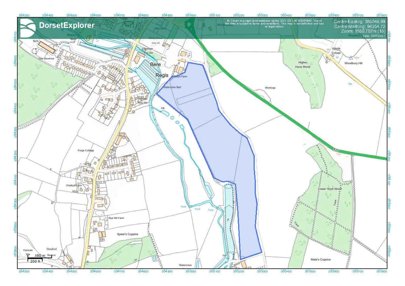
Delivery - correspondence from Dorset Wildlife Trust
Name of proposal: French's Farm, Upton
137. Nature of proposal: Heathland infrastructure project – Expand the existing French’s Farm SANG to include further adjacent land to enhance its mitigation capacity.
138. Site area in hectares: Existing SANG covers 4.83 hectares, the proposed extension, including adjacent land, would add a further 4.2 hectares to the site area giving just over 9 hectares in total.
139. Length of public right of way created: Subject to agreement between the parties as part of finalising the design of the heathland infrastructure project[43].
140. Planning considerations: The site is positioned in north eastern Purbeck close to the A35 (Upton bypass) and the edge of the large built-up area that includes Poole, Bournemouth and Christchurch. The settlements of Upton and Lytchett Minster are closely related to the land being offered as an extension to the existing SANG. The enlarged SANG will be accessible on foot by those living in Upton[44] and will also be accessible by car by making use of the car park associated with the existing SANG. The sites are defined as part of the South East Dorset Green Belt. Planning permission would be required for a change in the land’s use. Subject to detailed assessments of the proposals, as a matter of principle the council considers that the proposed use as a heathland infrastructure project could take place in a manner which preserves the openness of the Green Belt and is consistent with purposes of including land within Green Belt (in accordance with paragraph 150. e) of the NPPF July 2021). The enlarged SANG is also positioned close to Poole Harbour habitat site.
141. Background: Wyatt Homes own/have an interest in the land identified as an extension to the existing SANG. The proposed extensions will enlarge the existing SANG and increase its capacity. The enlarged SANG is well placed to be accessed on foot and by car from nearby residents in Upton and Lytchett Minster. The council’s HRA has indicated that heathland infrastructure projects are likely to be effective in this part of Purbeck. An enlarged French’s Farm SANG would make a positive contribution to mitigating the impacts of further unplanned development in this part of Purbeck. The council has yet to complete a formal assessment of the enlarged SANGs capacity, but initial advice from Natural England suggests this could increase to a further 150 homes and have a sphere of influence of around 5km.
142. Delivery: Wyatt Homes have indicated to the council as a matter of principle that they would be prepared to co-operate in the delivery of an extension to the existing SANG. Negotiations between the council and Wyatt Homes have not concluded, but the council is satisfied that there is a high probability that heathland infrastructure project will be delivered at French’s Farm before the 31 March 2024. (The council has entered a Memorandum of Understanding (MoU) with Wyatt Homes in respect to the proposed extensions to the existing SANG).
Map to show possible HIP - French's Farm
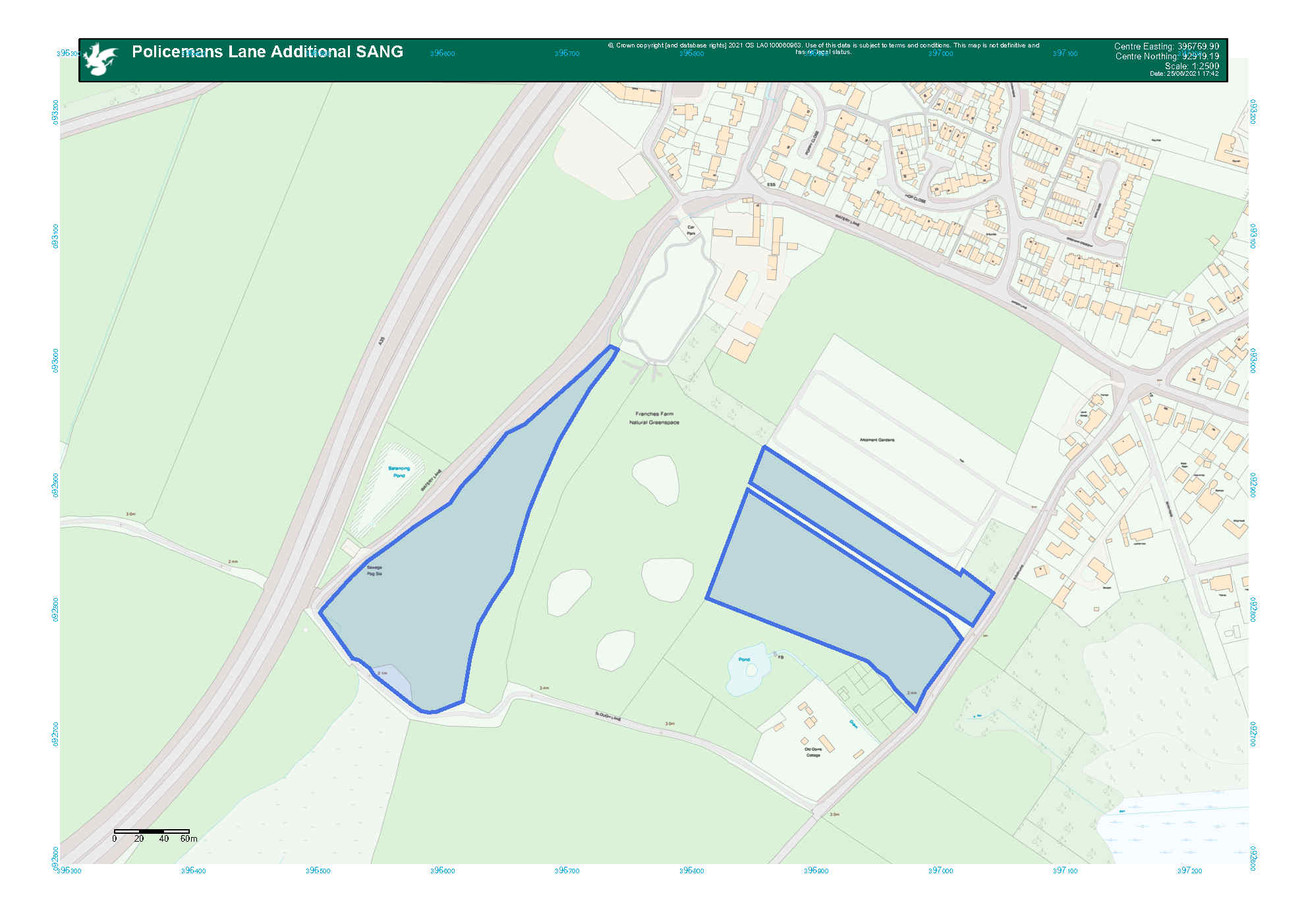
Delivery - correspondence from Wyatt Homes
Name of proposal: Land at Norden
143. Nature of proposal: Heathland infrastructure project – a project linked to the Purbeck Visitor Network that could include public recreational space.
144. Site area in hectares: Not defined.
145. Length of public right of way created: Not defined.
146. Planning considerations: The land around Purbeck Park (a council owned park and ride service positioned close to Corfe Castle in southern Purbeck), Norden is within the Dorset Area of Outstanding Natural Beauty. There are several habitats sites in vicinity of Purbeck Park including: Blue Poole and Norden Heaths and Hartland Moor. The land around parts of the Corfe River is also designated as Corfe Meadows Site of Special Scientific Interest.
147. Background: As part of the second phase of the Purbeck Visitor Network Project, the council is developing proposals that would see investment in a heathland support area around Norden. Land to the north of a council owned park ride at Norden near Corfe Castle may have potential for a heathland support area.
148. Delivery: Negotiations between the council and interested parties are at an early stage. Dorset Council is confident that negotiations will conclude positively however it is not certain that the heathland infrastructure project will be delivered before the end of March 2024.
Map to show broad location of possible HIP - Land at Norden
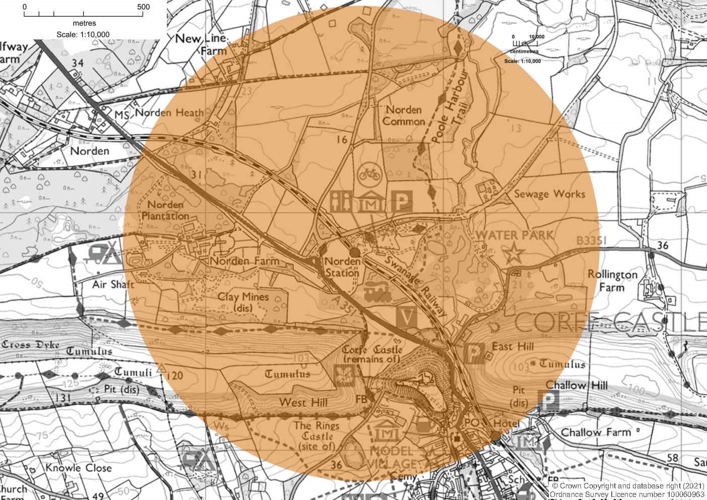
Name of proposal: Land to the east of Gore Heath
149. Nature of proposal: Heathland infrastructure project – the project could include several fields positioned to the east of Gore Heath.
150. Site area in hectares: Not yet defined (the council has identified an area of search on the map below). In total the land which the council is considering covers approximately 37 hectares.
151. Length of public right of way created: Not yet defined (as above).
152. Planning considerations: Positioned in northern Purbeck to the south of the A35 corridor. The land is within the South East Dorset Green Belt. Planning permission would be required for a change in the land’s use. Subject to detailed assessments of the proposals, as a matter of principle the council considers that the proposed use as a heathland infrastructure project could take place in a manner which preserves the openness of the Green Belt and is consistent with purposes of including land within Green Belt (in accordance with paragraph 150. e) of the NPPF July 2021). There are several Dorset heaths habitat sites in close proximity including: Morden Bog and Hyde Heath and Holton and Sandford Heaths.
153. Background: The council is carrying out initial investigations to determine the suitability and availability of land to the east of Gore Heath as a heathland infrastructure project. The site is positioned close to the proposed strategic SANG at Morden. The council’s HRA indicated that northern Purbeck was a suitable location for heathland infrastructure projects. The site is also well related to holiday caravan sites (Wareham Forest Lodge Retreat, Tanglewood and Sandford Holiday Park) and Organford Manor Country Park Homes (a residential park home site). Guidance from Natural England suggested that the proposed SANG at Morden would contribute to bringing the protected habitat sites into a favourable condition by intercepting people from visiting Dorset heath habitat sites to the west. There would be potential to form an access from Gore Fields Lane (which connects with the public right of way running from the car parking area near to Sherford Bridge) which would allow this land to function in a similar manner.
154. Delivery: Negotiations between the council and interested parties have not yet started. There is no certainty that a heathland infrastructure project will be delivered before the end of March 2024.
Map to show broad location of possible HIP - Land to the east of Gore Heath
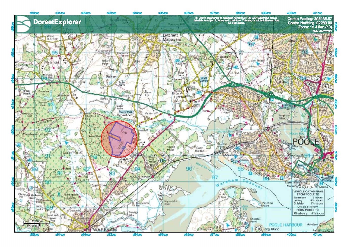
Name of proposal: Pike's Farm Organford Manor
155. Nature of the proposal: Heathland infrastructure project – A dedicated area of publicly accessible land where people will have the opportunity to exercise their dogs.
156. Site area in hectares: The design of the proposed heathland infrastructure project has yet to be finalised (once finalised it may include part of the area identified in the plan below) (On the basis of initial discussions the council estimates that the proposed SANG could extend to cover 10 hectares).
157. Length of public right of way created: Subject to agreement between the parties as part of finalising the design of the heathland infrastructure project.
158. Planning considerations: The site is positioned in northern Purbeck close to the A35. It is well related to the settlements of Upton, Lytchett Minster, Lytchett Matravers and Holton Heath. There is also good vehicular access to the site along the A35 from the western edge of the Bournemouth, Christchurch and Poole conurbation. The site is defined as part of the South East Dorset Green Belt. Planning permission would be required for a change in the lands use. Subject to detailed assessments of the proposals, as a matter of principle the council considers that the proposed use as heathland infrastructure project could take place in a manner which preserves the openness of the Green Belt and is consistent with purposes of including land within Green Belt (in accordance with paragraph 150. e) of the NPPF 2021). There is currently no public access onto the land being considered for a heathland support area.
159. Background: The site is owned by the Bournemouth Canine Association, the council is in negotiations around the potential to deliver a heathland infrastructure project which will offer mitigation for Dorset heaths habitat sites in northern Purbeck (the council’s HRA has highlighted this part of Purbeck as a suitable location for heathland infrastructure projects, and strategic SANG) next to the A35 corridor. In conjunction with existing heathland infrastructure projects (Upton Country Park, Upton Woods and Frenches Farm SANGs) the proposals at Organford Manor to the west of the conurbation would have the potential to intercept visitors before they reach the Wareham Forest habitat sites.
160. Delivery: Negotiations between the landowner and the council have not concluded – it is therefore not clear at present how much land would be made available for HIP or its mitigation capacity. The landowner has given their indication as a matter of principle that they are prepared to work with the council toward delivery of a heathland infrastructure project. Taking account of the need to obtain planning permission, the council is satisfied that there is a strong chance that a heathland infrastructure project could be delivered at Pikes Farm before the end of March 2024. (The council has entered a Memorandum of Understanding (MoU) with Bournemouth Canine Association in respect to the proposed SANG).
Map to show broad location of possible HIP - Pike's Farm Organford Manor
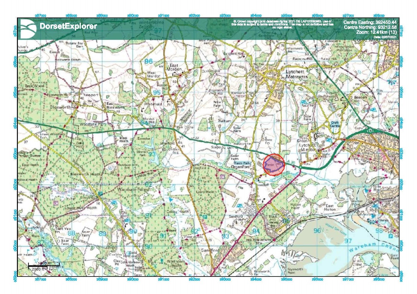
Delivery correspondence from the Bournemouth Canine Association
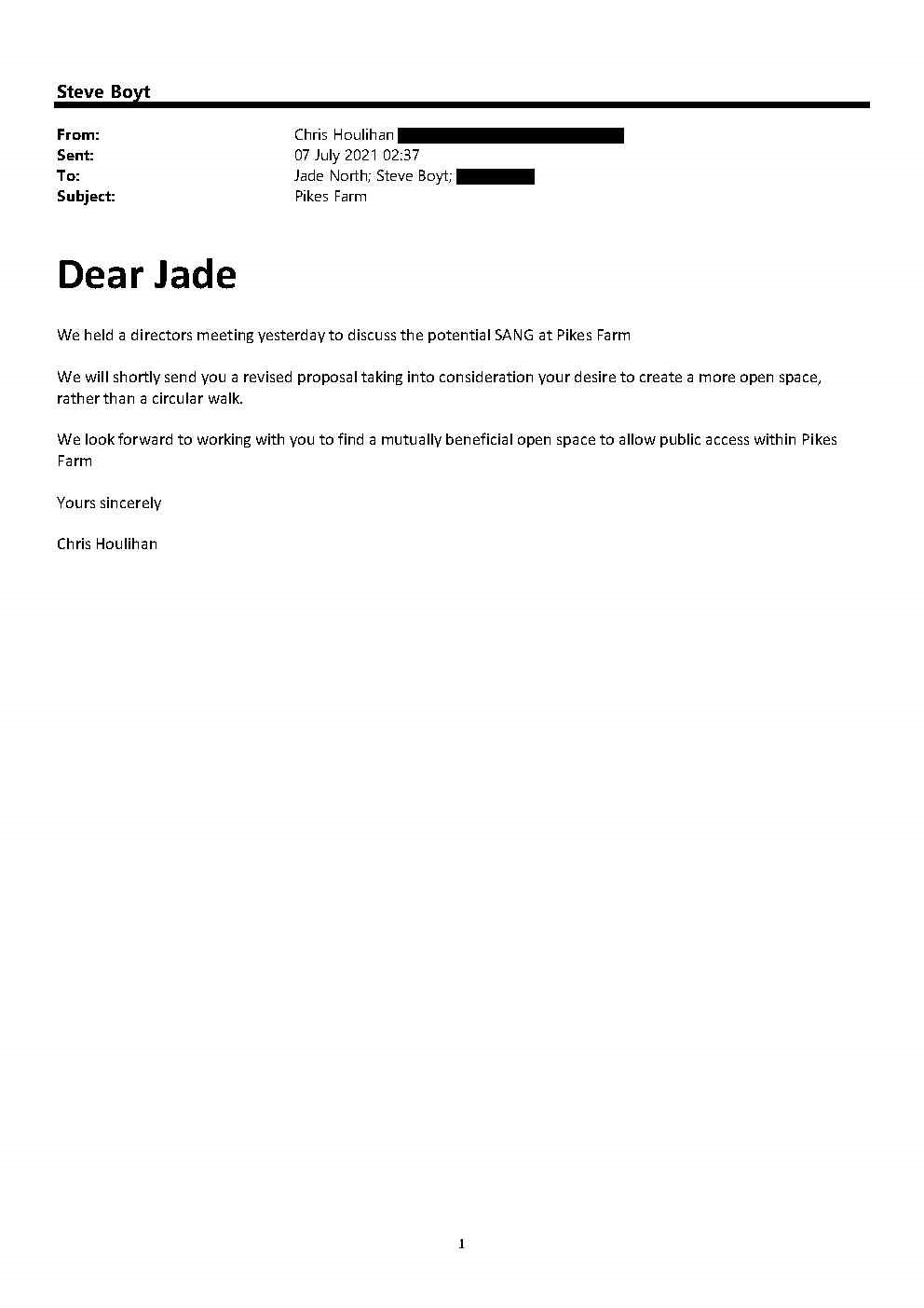
Name of proposal: Purbeck Heaths Visitor Project
161. Nature of proposal: Heathland infrastructure project – enhancing and creating access to ‘reliant areas’ to reduce pressure on Dorset heaths habitat sites.
162. Site area in hectares: Not applicable (the project primarily relates to the existing public rights of way network).
163. Length of public right of way created: The proposals include a mix of enhancement (majority of proposals) to existing rights of way and formation of new rights of way. In total rights of way which the council proposes to enhance/form extend to around 11.6 kilometres.
164. Planning considerations: The land where the council proposes to enhance existing rights of way, and form new rights of way, is within the Dorset Area of Outstanding Natural Beauty. Several the rights of way run close to designated heritage assets (including Corfe Castle Scheduled Monument, conservation areas and listed buildings). Some rights of way are also closely related to habitat sites including: Blue Poole and Norden Heaths, Hartland Moor and Povington and Grange Heaths) and Sites of Special Scientific Interest (Purbeck Ridge (East)). Some of the proposed work to enhance and form public rights of way may require planning permission.
165. Background: The project seeks to increase the effectiveness of SANG by enhancing and creating rights of way between SANG and other resilient areas. The council anticipates that the proposed network will enhance choice, provide longer walking routes and contribute toward drawing recreational pressure from habitat sites. For example the council will improve access along existing rights of way to the Washpond Natural Greenspace (Swanage SANG) and connections between ‘Purbeck Park’ (a park and ride facility on council owned land at Norden close to Corfe Castle) and the chalk ridge way that runs across the Isle of Purbeck. The council intends to invest in waymarking, improvements to the surfacing of rights of way, culverting and interpterion to encourage use. The council has not specifically defined the contribution that this project would make to mitigating the impacts on Dorset heaths habitat sites.
166. Delivery: The initial phases of this project can be delivered by July 2022. (The delivery rates for the different elements of the visitor project are likely to vary. For example the council has suggested that the improvements in access to Bog Lane – which form part of the wider visitor project - might not be delivered until March 2024).
Map to show proposed HIP - Purbeck Heaths Visitor Project
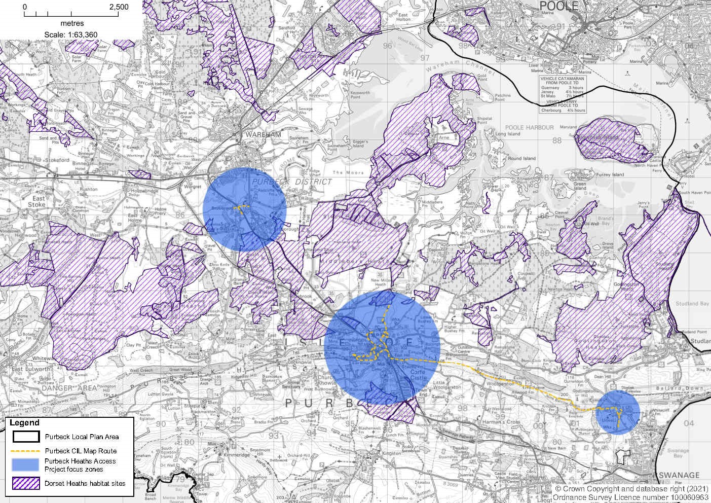
Name of proposal: Purbeck Visitor Management Project
167. Nature of proposal: Heathland infrastructure project – ditching and banking to managed access onto Hartland Moor Dorset heaths habitat site.
168. Site area in hectares: Not defined.
169. Length of public right of way created: No public rights of way will be created.
170. Planning considerations: The areas where the council proposes to form ditches and banking are within the Dorset Area of Outstanding Natural Beauty. The proposed ditches and banks will be formed adjacent/within Hartland Moor habitat site. The council has not specifically defined the contribution that this project would make to mitigation of impacts on Dorset heaths habitat sites.
171. Background: The council proposes to implement changes to roadside parking areas to manage visitor access to habitat sites in a manner which will mitigate damaging recreational activities. The proposed mitigation will specifically relate to stretches of Soldiers Road, Arne Road and Norden Road which are adjacent to Hartland Moor and Slepe Heath. The proposed engineering work will include formation of new ditches and banking to limit car parking and control access. Planning permission would be required to form the proposed ditches and banks next to the roads described above. The council also intends to erect signage to discourage harmful recreational activity.
172. Delivery: This project can be delivered by July 2022.
Map to show proposed HIP - Purbeck Visitor Management Project
Name of proposal - Sherford Bridge car parking area
173. Nature of the proposal: Heathland infrastructure project - To introduce measures (potentially comprising earth bunding, boulders and gates) to limit vehicle access to the existing informal car parking area.
174. Site area in hectares: Approximately 0.04 hectares.
175. Length of public right of way created: No public right of way created.
176. Planning considerations: The land is within the South East Dorset Green Belt. Planning permission would be required for the proposed engineering works to control access to the car parking area. The council would need to reach a conclusion as to whether any engineering works preserved the openness of the Green Belt and were consistent with defining land as Green Belt (paragraph 149 b) of the NPPF July 2021). The council may need to go on to consider whether there might be very special circumstances which clearly outweighed harm arising from any inappropriate development. There are several Dorset heaths habitat sites in close proximity including: Morden Bog and Hyde Heath and Holton and Sandford Heaths.
177. Background: The adjacent Gore Heath is leased by Forestry England and, covers approximately 176 hectares. The proposed site for HIP is located in northern Purbeck close to the proposed Morden Strategic SANG. The western side of the heath is adjacent to Morden Road (B3075) and there are three publicly accessible car parking areas from this road. The first is at the southwestern end of the site, the second smaller parking area is in the northern part of the site and the final car parking area is next to the site’s north eastern corner. Natural England have advised that in total these car parks have capacity for around 52 cars. These proposals relate to the car parking area positioned next to the sites north eastern corner. This car park is also closely related to a public right of way which runs to the east (adjacent to the northern boundary of Gore Heath) and west. To the west, this right of way initially runs parallel with the boundary of Morden Bog and Hyde Heath (Dorset Heathlands Special Protection Area, Dorset Heaths Special Area Conservation and Dorset Heathlands Ramsar) before splitting. One branch of the right of way (Hardy Way) runs south through the habitat sites. Natural England note in their letter, of the 26 July 2019, that the main function of the proposed Morden SANG would be ‘… in intercepting existing residents using the c.52 car park spaces along the Morden Bog/Wareham Forest B3075 access points.’ The council is exploring the potential to develop and implement measures to control access to the car parking area next to the north western corner of Gore Heath to manage access to the closest public right of way which gives direct access around and into Morden Bog and Hyde Heath. As part of this, work will be undertaken jointly between Forestry England and Dorset Council as the highways authority.
178. Delivery: The council has not been able to identify the landowner of the car parking area to the north east of Gore Heath – for this reason there is some uncertainty around whether it might be able to deliver the proposed measures outlined above before the end of March 2024.
Map to show possible HIP - Sherford Bridge car parking area
Name of proposal: Wareham Common
179. Nature of proposal: Heathland infrastructure project – to support enhanced access onto and around existing public access land.
180. Site area in hectares: Approximately 32.45 hectares.
181. Length of public right of way created: Proposals will enhance access on existing public access land.
182. Planning considerations: No material change in the land’s use would be required to support recreational access as the land is defined as Registered Common. The common is within the South East Dorset Green Belt and parts are within Wareham Common Site of Special Scientific Interest (SSSI). Any proposals to encourage access would need to be managed in a way which avoided adverse impacts on the SSSI.
183. Background: Wareham Common is to the north and north east of Wareham’s historic town centre. The council’s HRA has identified the common as a broad location that might be suitable site for heathland infrastructure projects, including a strategic SANG. It is split into three separate parcels by the railway line and the A351 which run around the north western edge of Wareham’s historic centre. In total these parcels cover approximately 32.45 hectares. There are several existing public rights of way running across this land which is also affected by flooding (making some parts inaccessible). The position of the railway line/A351, flood risk and designation as SSSI are all likely to limit the amount of land which will be suitable as a heathland infrastructure project and will determine its design. The council will investigate the suitability (in conjunction with Natural England) and deliverability (with the landowner) of HIP on Wareham Common.
184. Delivery: The council has made advances to the landowners but there is not currently any certainty that a heathland infrastructure project could be delivered at Wareham Common before the end of March 2024.
Map to show broad location of possible HIP - Wareham Common
Defining the heathland infrastructure projects needed to mitigate the impacts of completed and expected development during the interim period
185. The council has identified that the deficit in heathland infrastructure projects relates to 601.2 homes that have been, or are expected to be delivered, during the interim period up to 2023/24. Natural England provide the council with guidance on the relative efficiency of heathland infrastructure projects in mitigating the impacts of residential development. This is normally presented as a ‘capacity’ figure expressed in numbers of households. In specific reference to SANGs paragraph 28 of SD93 states that their capacity is affected by: ‘their natural features, size, design and their spatial relationship with homes and European sites.’
186. Paragraph 29 of SD93 clarifies that:
‘The starting point for Natural England’s assessment of SANG capacity involves applying a ratio of 16ha per 1000 population. This calculation is then adjusted to take account of the housing site’s/SANG’s location, the SANG’s natural interest features (attractiveness) and site constraints, e.g. an attractive SANG on the doorstep of a new development with no site constraints, such as SNCI (Site of Nature Conservation Interest) would have a greater capacity than a site at a distance with constraints.’
187. Elsewhere in England Natural England have provided guidance to councils in the Thames Basin that a ratio of 8 hectares [45] (ha) per 1000 population could be applied as the starting point for determining SANG capacity (Thames Basin Heaths Special Protection Area Avoidance Strategy Review 2016, paragraph 5.7).
188. Using the benchmark ratios outlined above, the table below summarises the lower and upper requirement for SANG (expressed in ha) for the 601.2 homes that require HIP during the interim period. The council has assumed that there are approximately 2.42 persons per household (this occupancy rate is used elsewhere by the council in its ‘Nitrogen Reduction in Poole Harbour Supplementary Planning Document’). The council has selected the occupancy rate for houses rather than flats as the majority of extant minor and major permissions (which form the majority of development requiring mitigation during the interim period) also relate to houses rather than flats (Appendix 7)[46].
Table 14: Upper and lower size limits for SANG required to mitigate the 'deficit' of 601.2 homes during the interim period.
| Benchmark ratio | Size of SANG required to act as mitigation to mitigate the deficit of 601.2 homes |
|---|---|
| 8 ha of SANG per 1000 population or 413 households | 11.6 ha |
| 16 ha of SANG per 1000 population or 413 households | 23.3 ha |
189. The council has high confidence around the delivery of the:
a) proposed SANG identified at Bere Heath, Court Farm which would extend to around 11 hectares; and
b) proposed extension to the existing French’s Farm SANG which would add a further 4.2 hectares.
190. Collectively these SANG would have capacity to mitigate the impacts of 784.7 homes applying the lower the benchmark ratio of 8 ha of SANG per 1,000 population/413 households. Or 392.4 homes applying the upper benchmark ratio of 16 ha of SANG per 1,000 population/413 households. Applying the lower benchmark ratio of estimated capacity would give a surplus of mitigation for the 601.2 homes delivered/expected during the interim period. Applying the higher benchmark ratio would give a deficit in mitigation capacity over the same period – expressed as 208.85 households.
191. In practice the final capacity of the proposed SANG will be affected by their natural features, size, design and their spatial relationship with homes and European sites. As the detailed design is to be determined, the council considers that it is reasonable to conclude that the proposed SANG are likely to have a mitigation capacity that ranges between 392.4 and 784.7 homes.
192. The council also has high confidence around the delivery of the heathland visitor and visitor management projects, and its ability to secure excess mitigation capacity from Wyatt Homes (measured at 100 households). Collectively it considers that the proposed SANG, visitor/visitor management projects, the arrangement to secure excess capacity from the Lytchett Matravers SANG and SAMM will mitigate the impacts from the 601.2 homes delivered/expected during the interim period.
193. The council has also outlined other opportunities to secure excess mitigation capacity from the Bog Lane SANG and to bring forward the heathland support area (identified as mitigation for the Moreton Station/Redbridge Pit housing allocation) to the north of Winfrith Heath to provide temporary mitigation for homes delivered/expected during the interim period. It is also working with Bournemouth Canine Association to bring forward a proposed SANG at Pike’s Farm, Organford Manor (the council estimates that the proposed SANG could extend to 10 hectares). These other heathland infrastructure projects provide contingencies to explore in the event of unforeseen issues around the delivery of the projects outlined above and the necessary confidence around delivery for the council’s 5-year housing land supply (as identified in MMCD5 which extends beyond the interim period to the monitoring year 2024/25). The council also expects the Dorset Council Local Plan to be adopted by 2023 before the end of the monitoring period identified in the latest 5-year housing land supply report. The council is confident that the approach in the interim mitigation strategy is robust and resilient.
Conclusion - interim approach to habitat site mitigation
194. The council recognises that further work is needed to determine the suitability and deliverability of the heathland infrastructure projects which will serve as mitigation during the interim period pending adoption of the Dorset Council Local Plan. Recognising this, as a matter of principle the Council is confident that some/all these mitigation projects will be delivered in a timely manner during the interim period.
195. More specifically the evidence presented above demonstrates that there is a high degree of certainty that in addition to SAMM, and site specific SANG for the proposed allocations, the following habitat site mitigation projects are likely to be delivered:
- Securing excess mitigation capacity from the Lytchett Matravers SANG (estimated capacity 100 homes);
- Delivering a 4.2 hectare extension to French’s Farm SANG;
- Delivering a 11 hectare heathland infrastructure project at Bere Heath;
- Delivering Purbeck Heaths Visitor Project; and
- Delivering Purbeck Visitor Management Project
196. Collectively the council is satisfied that these projects will mitigate the impacts from the 601.2 homes that have been and are expected to be delivered between 2018/19 and 2023/24. (See Memorandums of Understanding between the council and relevant landowners on these matters for further clarification). The council will also continue to explore the potential to deliver heathland infrastructure projects at Sherford Bridge car parking area, Pikes Farm, Gore Heath, Land at Norden and the proposed strategic SANG identified on the local plan policies map at Morden. Subject to guidance from Natural England, the council will also continue to pursue negotiations with the Moreton Estate around delivery of the heathland support area in advance of the housing allocation.
197. Through a Memorandum of Understanding with Natural England, the council commits to review delivery of those proposed heathland infrastructure projects outlined in this paper.
198. Over the interim period, pending adoption of the Dorset Council Local Plan, the Council is satisfied that through continued delivery of strategic access management and monitoring and the proposed heathland infrastructure projects, that the potential impacts of development in the Purbeck area can be mitigated.
Implications for the Purbeck Local Plan 2018-2034
199. Due to the representations received and the council’s acceptance of their merit, further changes are needed to the plan.
200. Appendix 5 outlines the Further Proposed Main Modifications which the council proposes to Policies V2, I5 and related supporting text. The council also proposes to amend the local plan inset policies map relating to Morden by taking out reference to the land identified for release from the Green Belt (in relation to Policy V2) and the land identified as holiday park (in relation to Policy I5).
201. A number of other planning policies, and supporting text, also refer to Policies V2 and I5. Appendix 6 outlines a series of Consequential Further Proposed Main Modifications that are necessary to reflect the changes to Policies V2 and I5.
Conclusions
202. To conclude, the council considers that the some of the matters and issues raised through representations to the Main Modifications consultation have merit. The council considers that the implications of Further Proposed Main Modifications, which are suggested to address these matters and issues, can be addressed through alternative mitigation strategies which it considers are suitable for offsetting impacts on the Dorset heaths habitat sites during the interim period pending adoption of the Dorset Council Local Plan.
Appendix 1
Natural England's letter of 26 July 2019
Appendix 2
Correspondence between the council and the Moreton Estate in respect to the proposed heathland support area to the north of Winfrith Heath (Tadnoll)
Appendix 3
Proposed Main Modifications (November 2020 to January 2021) relating to policies V2: Green Belt and 15: Morden Park strategic suitable alternative natural green space (SANG) and holiday park
Appendix 4
Summary of the screening for likely significant effects and proposed mitigation strategy undertaken for the Purbeck Local Plan Part 1 and through consultations relating to the review of the Purbeck Local Plan Part 1 (2015, 2016 and 2018)
Purbeck Local Plan Part 1 (2012)
203. The Purbeck Local Plan Part 1 was adopted in November 2012. It included a strategy for delivering 2,520 homes over the plan period (2006 to 2027). Using Policy HS: Housing Supply, the sources of supply are summarised in the table below.
Table 15: Summary of sources of housing land supply between 2006 and 2027 Purbeck Local Plan Part 1 (2012) (Policy HS: Housing Supply).
| Source of supply | Total number of homes |
|---|---|
| Completions | 830 |
| Commitments | 280 |
| Character area potential | 710 |
| Council owned sites | 50 |
| Settlement extensions | 570 |
| Windfall | 80 |
| Total | 2,520 |
204. The council divided Purbeck into five spatial areas (North West, South West, Central, North East and South East). The table below summarises the spatial distribution of homes according to the source of supply.
Table 16: Spatial distribution according to sources of supply Purbeck Local Plan Part 1 (Policy HS: Housing Supply). (**A settlement extension at Bovington is not included in the total figures because dwellings will be military housing and not for sale on the open market).
| Table 16 | Completions | Commit-ments | Character area potential | Settlement extension | Council owned | Windfall | Total |
|---|---|---|---|---|---|---|---|
| North West | 30 | 10 | 20 | 50 | 10 | 120 | |
| South West | 240 | 40 | 70 | 30** | 10 | 360 | |
| Central | 50 | 40 | 160 | 200 | 10 | 15 | 475 |
| North East | 230 | 30 | 200 | 120 | 25 | 605 | |
| South East | 280 | 160 | 260 | 200 | 40 | 20 | 960 |
| Total | 830 | 280 | 710 | 570 | 50 | 80 | 2520 |
205. Policy HS estimates that 725 homes (approximately 29%) will be delivered in northern Purbeck, 475 homes (approximately 19%) in central Purbeck and 1,320 homes (approximately 52%) in southern Purbeck.
206. The Habitats Regulation Assessment (HRA) (2011) for the Purbeck Local Plan Part 1 screened Policy HS: Housing Supply as giving rise to likely significant effects on Dorset Heaths (including Dorset Heaths (Purbeck and Wareham) and Studland Dunes SAC, the Dorset Heathlands SPA and the Dorset Heathlands Ramsar) (Habitats Regulation Assessment of the Purbeck Core Strategy, Proposed Changes to the Pre-submission Version, Sept 2011, Table 1).
207. The 2011 HRA analyses travel times (from trips made using a vehicle) to access Dorset Heaths from various locations across Purbeck. The HRA concludes that ‘Map 3 shows that all of Purbeck District is within 25 minutes (or less) drive of an access point onto a heath. All new development within the strategy (i.e. 2400 houses) is within 15 minutes’ drive of a heath.’ (Paragraph 5.29).
208. The HRA goes on to outline mitigation measures needed to avoid adverse impacts on the integrity of Dorset Heaths. These include:
- Strategic Access Management and Monitoring (SAMM). These measures include discouraging access at particular sites, encouraging use of alternative sites which are not protected (making certain sites harder to access and encouraging access at others) and wardening; and
- Suitable Alternative Natural Greenspaces (SANG)
209. At paragraph 5.51 the HRA states that ‘The characteristics of the heaths (large attractive sites with views) and spatial distribution of development in Purbeck (scattered across a number of settlements), indicate that SANG provision needs to be delivered by a small number of well located, large sites, each sufficient to ‘compete’ with the heaths.’ (Paragraph 5.51).
210. Paragraph 5.52 goes onto identify three ‘ideal’ broad locations for SANG. These include: in the north of the district (between Lytchett Matravers and Bere Regis or to the north of Bere Regis, in order to provide opportunities for recreation for residents of Bere Regis and Lytchett Matravers), near Wareham (drawing new residents away from sensitive locations within Wareham Forest and Hartland/Stoborough/Arne) and to north of Studland.
Purbeck Local Plan (2018-2034)
Habitats Regulation Assessment of the Partial Review of the Purbeck Local Plan Part 1; Issues and Options (2015)
211. The issues and options consultation sought representation on proposals to deliver 2,244 new homes over the plan period [1] (option 2a) or to deliver 2,244 new homes over the plan period (option 2b). The HRA considered the suitability of mitigation measures put forward for the proposed housing allocations. At the time the HRA was undertaken the predecessor district and unitary councils in Dorset were reviewing the ‘Dorset Heathlands Planning Framework 2012-2014’.
212. At paragraph 4.13 the HRA states that: ‘…at the moment it is not clear how the mitigation in Purbeck will be delivered. Without the details in the forthcoming SPD it is not possible to complete the appropriate assessment.’
213. The HRA included an appropriate assessment for ‘Country Park and Tourist Accommodation at Morden’ (page 55). It considered the option for delivering between 80 to 100 holiday chalets and a large area of public open space. The assessment considered the possible origins of visitors to the proposed public open space using visitor survey data relating to Sherford Bridge (the data was collected in 2008 and 2014 [Wild Purbeck NIA visitor work]). Map 11 of the HRA suggests visitors to Sherford Bridge originate from the following broad areas within Purbeck: Lytchett Matravers, Upton and Wareham. (The is also shows a small cluster of visitors originating from Bere Regis and the villages between Bere Regis and Lytchett Matravers [Morden, Bloxworth etc.]). Outside Purbeck there is a reasonably even spread of visitors originating from across Poole and a small cluster of visitors originating from Corfe Mullen.
214. The HRA states that ‘It can be seen that the SANG could function well in terms of drawing residents from Upton, Lytchett Minster and the west of Poole in particular.’ (Paragraph 8.5).
Habitats Regulations Assessment of the Partial Review of the Purbeck Local Plan Part 1; Options
215. The HRA gave screening assessments for each emerging policy and proposed allocations for development in the Options document. The need for new homes was re-assessed for the options at 3,080. In addition to those planned for in Purbeck Local Plan Part 1 (2,520) this gave rise to a need for 5,600 new homes up to 2033 (or 238 new homes each year).
216. The HRA comments on the effectiveness of SANG delivered with the settlement extension to Wareham (known as Westgate) and Upton. (Paragraphs 4.16 and 4.17). It reiterates many of the issues identified in the 2015 HRA in respect to ‘Country Park and Tourist Accommodation at Morden’ (pages 56 to 58). At paragraph 7.7 the HRA states that: ‘At present it is concluded that it may be possible for the Country Park to function as a strategic SANG and in some ways the location is ideal. New facilities here could be linked with management of roadside parking along the B3075 to better manage access across this part of Wareham Forest. As such there are some clear positive benefits for the European sites. Potential constraints relate to the chalet accommodation and how these can be made compatible with the SANGs delivery.’
Habitats Regulations Assessment of Revised Housing Options for the Purbeck Local Plan Review (2018)
217. As with earlier HRA this iteration provided screening assessments for policies and proposed allocations for development in the Options document. The council reassessed housing need for the consultation. The revised assessment was for 2,890 new homes between 2016 and 2033 (or 170 new homes each year).
218. The council introduced a proposed housing policy through the options consultation that would permit small numbers of homes around existing settlements. The council was not able to provide detailed evidence around the distribution of homes on these small sites. The council estimated that around 220 new homes could be delivered on small sites. The HRA states that: ‘There will be a need to include reference to European site mitigation as part of this new policy, and it should also recognise that project level HRA will be required, and some locations may not be able to rule out adverse effects on European sites.’ (Paragraph 5.26).
Appendix 5
Further Proposed Main Modifications (Winter 2021) relating to Policies V2: Green Belt and I5: Morden Park strategic suitable alternative natural green space (SANG) and holiday park, and their supporting text
Appendix 6
Consequential Further Proposed Main Modifications
Appendix 7 - Mix between houses and flats in those minor and major sites with planning permission in Purbeck
Permissions Minor
Table 17: Permissions minor identified in the councils 5-year housing land supply report (MMCD5) with clarification on dwelling type.
Site location |
Planning Reference |
Commitment left on site |
House or flat |
||
|---|---|---|---|---|---|
Seabank Lodge, 4 Ulwell Road, Swanage, BH19 1LH |
6/2017/0176 |
2 |
Flats |
||
Hillcrest, 8 Durlston Road, Swanage, BH19 2DL |
6/2018/0577 |
4 |
Houses |
||
37 Commercial Road, Swanage |
6/2015/0727 |
1 |
House |
||
5- Land adjacent to Olive Cottage, Cliff Place, Marshall row BH19 2PL |
6/2016/0733 |
1 |
House |
||
Land adjacent to 1A Battlemead, Swanage, BH19 1PH |
6/2019/0492 |
1 |
House |
||
15C Commercial Road, Swanage, BH19 1DF |
6/2018/0076 |
1 |
Flat |
||
68 Queens Road, Swanage, BH19 2EX |
6/2016/0472 |
1 |
House |
||
3 Highcliffe Road, Swanage, BH19 1LW |
6/2016/0276 |
1 |
Flat |
||
Knapp Stores Limited, 198 High Street, Swanage |
6/2017/0439 |
2 |
Houses |
||
The Pier Head, 1 High Street, Swanage BH19 2AQ |
6/2017/0293 |
6 |
Flats |
||
4 Russell Avenue, Swanage, BH19 2EB |
6/2019/0045 |
1 |
House |
||
29 South Road, Swanage, BH19 2QR |
6/2017/0448 |
1 |
House |
||
78 Ulwell Road, Swanage, BH19 1LN |
6/2018/0411 |
1 |
House |
||
Castleton Hotel 1 Highcliffe Road Swanage BH19 1LW |
6/2018/0447 |
1 |
House |
||
Land to the rear of 15 Sydenham Road, Swanage, BH19 2JX |
6/2018/0226 |
1 |
House |
||
The Reading Room, 36 Bell Street, Swanage, BH19 2SA |
6/2019/0073 |
1 |
House |
||
128-132 High Street, Swanage, BH19 2PA |
6/2018/0105 |
1 |
House |
||
251 High Street, Swanage, BH19 2NG |
6/2018/0556 |
2 |
Flats |
||
Newsquest Hampshire, 21B Commercial Road, Swanage, BH19 1DF |
PDD/2019/0001 | 1 | Flat | ||
27 Station Road, Swanage, BH19 1AD |
6/2019/0366 | 1 | Flat | ||
Park Farm Cottage, Poole Road,Upton, BH16 5LW |
6/2017/0323 | -1 | House | ||
625 Blandford Road, Upton, Poole, BH16 5ED |
6/2017/0400 | 1 | House | ||
71 Dorchester Road, Upton BH16 5NN |
6/2018/0207 | 1 | House | ||
78 Dorchester Road Upton, BH16 5NT |
6/2017/0119 | 1 | House | ||
Store to r/o 18 & 20 South Street, Trinity Lane, Wareham |
6/2015/0475 | 1 | House | ||
West Mill Farm, Wareham Common, Wareham, BH20 6AA |
6/2018/0084 | 1 | House | ||
Cottee and son, East Street, Wareham, BH20 4NR |
6/2018/0611 | 9 | Houses | ||
18 West Street, Wareham BH20 4JX |
6/2019/0192 | 4 | Flats | ||
132 Northmoor Way, Wareham |
6/2019/0397 | 1 | House | ||
28 Tarrant Drive, Wareham, BH20 4EP |
6/2017/0440 | 1 | House | ||
35 Sherford Close, Wareham, BH20 4JL |
6/2018/0539 | 1 | House | ||
8 Egdon Road, Wareham, BH20 4DA |
6/2017/0307 |
1 | House | ||
9/9A Daniel Drive, Northmoor Park, Wareham, BH20 4RU |
6/2017/0232 |
1 |
House |
||
12 Daniel Drive, Wareham, BH20 4RU |
6/2017/0375 |
1 |
Flat |
||
33 North Street, Wareham, BH20 4AD |
6/2017/0747 |
1 |
House |
||
12 to 16 Bere Road, Wareham BH20 4DD |
6/2019/0589 |
4 |
Houses |
||
149 Northmoor Way, Wareham, BH20 4EH |
6/2019/0390 |
1 |
House |
||
17 South Street, Wareham, BH20 4LR |
6/2018/0043 |
1 |
Flat |
||
18 West Street, Wareham BH20 4JX (different app) |
6/2019/0185 |
1 |
House |
||
4 Lampton Close, Wool, Wareham, BH20 6EW |
6/2018/0404 |
1 |
House |
||
151 Roke Road, Bere Regis, BH20 7JF |
6/2017/0434 |
1 |
House |
||
6 Colliers Lane, Wool, Wareham, BH20 6DL |
6/2019/0241 |
1 |
House |
||
Land adjacent Caroline Cottage, Prospect Road, Lytchett Matravers, BH16 6ED |
6/2019/0548 | 2 | Houses | ||
3 Hopmans Close, Lytchett Matravers, Poole, BH16 6AY |
6/2018/0374 |
1 |
House |
||
The Barn, Bennic Farm, Dolmans Hill, Lytchett Matravers, Poole, BH16 6HP |
6/2018/0216 |
1 |
House |
||
Redbridge Farm, Dolmans Hill, Lytchett Matravers BH16 6HP |
PDA/2016/0002 |
1 |
House |
||
The Walled Garden, Colehill Road, Lytchett Matravers, Poole, BH16 6BS |
6/2018/0081 |
1 |
House |
||
169 Wareham Road, Lytchett Matravers, Poole, BH16 6EA |
6/2017/0206 |
1 |
House |
||
86 Wareham Road, Lytchett Matravers BH16 6DT |
6/2018/0362 |
2 |
Flats |
||
Former Royal British Legion Club, Wimborne Road, Lytchett Matravers, Poole, BH16 6HQ |
6/2018/0645 |
7 |
Houses |
||
Evergreen, Bailey's Drove, Wool |
6/2015/0547 |
1 |
House |
||
56 High Street, Lytchett Matravers BH16 6BH |
6/2019/0182 | 1 | Flat | ||
Northhouse Farm, Huntick Road, Lytchett Matravers, BH16 6BB |
6/2017/0061 |
2 | Houses | ||
Owls Farm, Dolmans Hill, Lytchett Matravers BH16 6HP |
PDA/2020/0001 | 1 | House | ||
The Shooting Box, Middle Road, Lytchett Matravers BH16 6HJ |
6/2019/0441 | 2 | Houses | ||
Whytewood Lodge, Jennys Lane, Lytchett Matravers, BH16 6BP |
6/2019/0453 | 1 | House | ||
16 Foxhills Crescent, Lytchett Matravers BH16 6BE |
6/2017/0511 | 1 | House | ||
Higher Loop Farmhouse, Loop Farm Road, Lytchett Matravers, BH16 6BU |
6/2017/0169 | 1 | House | ||
18 Green Close, Bere Regis, Wareham, BH20 7LW |
6/2018/0008 | 1 | House | ||
Old Dairy Cottage, Woolgarston Road, Corfe Castle, BH20 5JD |
6/2019/0561 | 1 | House | ||
88 West Street, Bere Regis, Wareham, Dorset, BH20 7HH |
6/2017/0419 | 1 | House | ||
12 King George V Road, Bovington BH20 6JQ |
6/2019/0247 | 3 | Flats | ||
53 Spring Street, Wool, BH20 6DB |
6/2019/0247 | 1 | House | ||
Bovington Shopping Centre, King George V Road, Bovington, BH20 6JQ |
6/2019/0523 | 7 | Flats | ||
Tanglefoot, East Burton Road, Wool, Wareham, BH20 6HF |
6/2019/0001 | 1 | House | ||
48 East Street Corfe Castle BH20 5EQ |
6/2019/0583 | 1 | House | ||
Bluebell Lodge, 142A Rye Hill, Bere Regis |
6/2018/0428 | 1 | Caravan | ||
Butchers Shop (and Galley), Main Road, West Lulworth BH20 5RL |
6/2018/0221 | 1 | House | ||
Land adj 8 Arundel Terrace, Langton Matravers |
6/2017/0343 | 1 | House | ||
| Home Farm, Dorchester Road, Winfrith Newburgh, Dorchester, DT2 8DD | 6/2019/0029 | 1 | House | ||
| The Science Block, The Old Malthouse School, High Street, Langton Matravers, Swanage, BH19 3HB | 6/2017/0226 | 2 | Houses | ||
Knoll Cottage Caravan Park, Gatemore Road, Winfrith Newburgh, Dorchester, DT2 8LD |
6/2018/0324 | 4 | Caravans | ||
West Lulworth C of E Primary School, School Lane, West Lulworth, Wareham, BH20 5SA |
6/2018/0653 | 9 | Houses | ||
Downshay Farm, Haycrafts Lane, Harmans Cross, Swanage, Dorset, BH19 3EB |
6/2017/0030 | 1 | House | ||
43 Corfe Road, Stoborough, BH20 5AD |
6/2019/0181 | 1 | House | ||
Abbascombe Farm, Worth Matravers BH19 3LF |
6/2018/0410 | 1 | House | ||
Plot at Kingston Lane, Worth Matravers, BH19 3LE |
6/2019/0470 | 1 | House | ||
Blackdown House Farm, The Hollow, Briantspuddle, DT2 7HX |
6/2018/0037 | 3 | Houses | ||
West Morden Dairy, Kings Lane, West Morden, BH20 7EA |
6/2015/0019 | 1 | House | ||
The Potting Shed, Glebe House, Bucknowle BH20 5NS |
6/2019/0340 | 1 | House | ||
1 Stockford Cottages, East Stoke, Wareham, BH20 6AN |
PDA/2019/0001 | 1 | House | ||
Hethfelton House, A352, Hethfelton, Dorset, BH20 6HS |
6/2017/0225 | -1 | House | ||
Barns at Woodstreet Farm, East Stoke |
6/2015/0281 | 3 | Houses | ||
Hill View Farm, Church Lane, East Stoke, BH20 6AW |
6/2017/0682 | 3 | Houses | ||
The Stable House & Adjacent Farm Buildings (part of Farmer Palmers Adventure Farm),Wareham Road, Organford, BH16 6EU |
6/2018/0674 | 1 | House | ||
Chapel Cottage, Kingston Hill, Kingston, BH20 5LG |
6/2019/0560 | 1 | House | ||
Kemps Country House, East Stoke, Wareham, BH20 6AL |
6/2019/0090 | 6 | Houses | ||
Worgret Manor, Worgret Road, Wareham BH20 6AB |
6/2017/0680 | 1 | Flat | ||
Former cow shed, West Burton Farm, Winfrith Newburgh, Dorchester, DT2 8DD |
6/2016/0333 | 1 | House | ||
| Total: 152 | 34 Flats | ||||
| 113 Houses | |||||
| 5 Caravans | |||||
Permissions Major
Table 18: Permissions major identified in the councils 5-year housing land supply report (MMCD5) with clarification on dwelling type.
| Site location | Planning Reference | Commitment left on site | House or flat | ||
|---|---|---|---|---|---|
| Compass Point, Land West of Northbrook Road, Swanage | 6/2017/0713 | 75 | Houses | ||
Former Playing Fields, Northbrook Road, Swanage |
6/2016/0769 |
51 | 9 Flats & 20 Houses | ||
| Former St Marys School, Manor Road, Swanage | 6/2018/0493 | 30 | 10 Flats & 20 Houses | ||
Rowlands Wait Caravan Park, access road to Blackhill Clump, Rye Hill, Bere Regis |
6/2018/0670 | 35 | Caravans | ||
Land adjacent to Wessex Water Reservoir, Purbeck Road, Lytchett Matravers |
6/2018/0287 | 25 | 5 Flats & 20 Houses | ||
| Land at Huntick Road, Lytchett Matravers | 6/2019/0460 | 46 | 14 Flats & 32 Houses | ||
Spyway Orchard, Durnford Drove, Lytchett Matravers |
6/2018/0606 | 28 | Houses | ||
Manor Farm Caravan Park, Church Lane, East Stoke |
6/2018/0675 | 34 | Caravans | ||
| Total: 324 | 38 Flats | ||||
| 217 Houses | |||||
| 69 Caravans | |||||
Footnotes
[1] Poole Harbour Recreation 2019-2024 Supplementary Planning Document, Nitrogen Reduction in Poole Harbour Supplementary Planning Document 1 April 2017 and Dorset Heathlands Interim Air Quality Strategy (March 2021).
[2] Natural England have also drawn attention to the council’s responsibility of bringing existing habitat sites into a favourable condition when exercising its functions.
[3] The council also assessed whether there were exceptional circumstances for release of enabling development at each of the three options in its pre-submission draft Green Belt study (SD56).
[4] The council did not use viability evidence to explicitly justify the limit on holiday units as minimum number of units required to enable delivery of the strategic SANG. The limit on the number of units was guided by design considerations, consultation with the landowner and the impacts of the development on habitat sites.
[5] Including North West Purbeck, North East Purbeck, South West Purbeck, South East Purbeck and Central Purbeck (see Map 6: Distribution of Housing Supply 2006-2027 (at 1 April 2011) of the Purbeck Local Plan Part 1 (2012).
[6] Local police and fire services have developed ‘Firesetters’ which is a targeted initiative aimed at working with children that encourages them to stop (extinguish) fires when they first appear.
[7] The council granted planning in January 2014 to ‘Erect 153 dwellings with associated open space, sewage pumping station, electricity sub-station and landscaping. Construct new vehicular and pedestrian accesses.’ (6/2013/0278).
[8] The applicant entered into a planning obligation ‘To provide the SANG Land to be operational and available for use by the public prior to the Occupation of the 1st Dwelling of the Development’ And ‘Not to cause or permit the Occupation of the 1st Dwelling of the Development until the SANG Land is operational and available for use by the public’. The SANG land is edged in blue on Plan 1 of the planning obligation and was subject to a separate planning application 6/2013/0285. Building work on the approved homes is now completed and the SANG is operational. The SANG is referred to as ‘Bog Lane SANG’.
[9] Planning permission allowed at appeal in November 2015 for ‘Erection of 70 dwellings with associated open space, noise attenuation bund, accesses and onsite roads/footpaths; off-site transport improvements including footpath along Policemans Lane; creation of sustainable drainage system including new pond; and use of land for recreational purposes (Suitable Alternative Natural Green Space).’ (6/2014/0299).
[10] The applicant entered a planning obligation with the council ‘to carry out the SANG Works in accordance with the approved SANG Land Maintenance and Management Plan and to complete the SANG Works prior to Occupation of the first Dwelling’. For the purposes of the planning obligation ’SANG Lane’ ‘means the land shown for identification purposes edged blue on the Plan.’ Building work on the approved homes is now completed and the SANG is operational.
[11] Planning permission granted May 2019 for ‘Erection of 46 dwellings (including affordable homes), new vehicular access via Huntick Road, associated landscaping, & all other development works’. (6/2018/0063). Work on implementing the planning permission has begun but no homes have been completed to date.
[12] In response on the planning application Natural England advised that ‘The application is of a size approaching the agreed threshold to require consideration of a Heathland Infrastructure Project. Natural England has carefully considered the scale, local green infrastructure, location and separation from the designated sites and concludes that in this case the authority can rely on the mechanism set out in the Dorset Heathlands Planning Framework 2015 - 2020 Supplementary Planning Document (SPD). Specifically the authority should secure the necessary mitigation sums for HIPs and SAMM from its CIL contribution of S106 prior to first occupation.’
[13] Outline planning permission (June 2014) and approval of reserved matters (May 2017) granted for ‘Demolition of existing house, construction of residential development of 52 units (50/50 mix market and affordable housing) with access via Northbrook Road - Reserved matters application seeking approval for access, appearance, landscaping, layout and scale.’ (6/2013/0150 & 6/2016/0769).
[14] Outline planning permission granted March 2021 for ‘Demolition of the former Grammar School and ancillary buildings and erection of 39 new dwellings with associated infrastructure’ (6/2019/0221)
[15] Planning permission granted for ‘Change of use of land from agriculture to public open space for use as suitable alternative natural green space.’ (6/2016/0278). The boundaries of the proposed SANG are contiguous with that delivered in respect to the development to the west of Northbrook. In total these SANG, which would serve both development, cover an area of 6.72 ha.
[16]Planning permission granted January 2019 for ‘Erection of 90 dwellings with access via Northbrook Road, associated landscaping, drainage and provision of a Suitable Alternative Natural Greenspace (SANG) to the north and south of Washpond Lane.’ (6/2017/0713).
[17] The Washpond Natural Greenspace opened to the public on Monday 16th September 2019. This SANG mitigates the effects of the consented 90 homes to the west of Northbrook Road. A contiguous extension to this operational SANG (giving a total area of 6.72 ha) would mitigate the effects from the consented 91 homes to the east of Northbrook Road.
[18] Planning permission granted November 2017 for ‘Demolition of existing farm buildings; the erection of 20 dwellings (including 7 affordable) comprising 13 detached homes, two semi-detached homes and a block of five flats; create new access, parking and landscaping.’ (6/2017/0359).
[19] For the purposes of this paper the council has combined the numbers of homes to be delivered as ‘character area potential’ with ‘windfall’ which are identified as two separate sources of supply in Policy HS: Housing Supply of Purbeck Local Plan Part 1.
[20] Outline planning permission was granted in October 2012 to ‘Erect 22 self-catering holiday lodges.’ (6/2012/0124). A condition was added to the 2012 permission limiting the number of tents permitted on site at any one time to 108. Reserved matters planning permission was granted in June 2014 to ‘Erect 22 self-catering holiday lodges - Reserved Matters.’ (6/2014/0159).
[21] The planning obligation includes a requirement ‘Not to Commence Development until full details for the provision and layout out the area edged orange on the Mitigation Plan as a woodland walk/nature trail (including erection of bird nesting boxes and bat roosting boxes) and an area for the walking of dogs and for use by the public have been submitted to the Council in consultation with Natural England.’ Paragraph 3 in the obligations indicates that the use of the area edged in orange on the mitigation plan be limited to ‘woodland walk/nature trail and an area for the walking of dogs by members of the public for so ever as the Self-catering Holiday Lodges are occupied or available for occupation under this Planning Permission.’
[22] See MMCD5: Five Year Housing Land Supply 2020 and the Housing Delivery Test: 2020 measurement, which provides the 2020 Housing Delivery Test measurement by local planning authority. 73 homes were delivered during the monitoring year 2018/19 and 148 homes were delivered during the monitoring year 2019/20.
[23] See table 13 below – in addition to SAMM mitigation, heathland infrastructure projects were also secured for 35 homes through SANG in Swanage.
[24] Each memorandum of understanding outlines HIP, in the form of SANG and heathland support area, capable of mitigating the impacts from the planned homes identified in the allocation.
[25] This total differs from the total presented in MMCD 5 as it does not take account of allocations in the Swanage Local Plan.
[26] The council has conducted an HRA of Wareham Neighbourhood Plan 2019-2034. Referring to a statement of common ground (entered into by the Scott Estate, Wareham Town Council and Natural England) the council’s HRA notes that: ‘The SoCG has agreed that, in association with the Westgate Development on Worgret Road a SANG that has been provided at Bog Lane, Stoborough has considerable additional capacity to mitigate new residential development. The area covers 14 ha and is suitably located with suitable capacity for the number of homes allocated in the Wareham Neighbourhood Plan, south of the railway. All parties of the SoCG are in agreement that with improvement this site would be a suitable consideration for mitigating the effects of increased recreational pressure upon the Dorset Heaths European sites.’ The HRA concludes: ‘It can therefore be concluded that all policies supporting residential development will not have an adverse effect on the integrity of the Dorset Heaths European sites in combination as a result of recreation pressure.’
[27] Outline planning permission granted March 2019 for ‘Residential development of up to 140 residential dwellings (including up to 35% affordable housing) together with associated infrastructure, access onto Frome Valley Road, children's play space, landscaping and creation of a Suitable Alternative Natural Green Space ("SANGS")(means of access to be determined only)’ (WD/D/17/003036). Construction of the homes has not begun.
[28] Planning application lodged February 2016 for: ‘Full planning permission for the erection of 99 open market dwellings & affordable dwellings, a new doctors’ surgery, a replacement village hall, a car park, a new village green, new vehicular and pedestrian accesses and works to Warmwell Road. An outline application for the erection of 401 open market and affordable dwellings, the provision of 2.5ha of employment land, new vehicular and pedestrian accesses, roads, footpaths and cycleways, a car park for the proposed Site of Alternative Natural Greenspace (SANG) and 2 pumping stations; and a full application for the change of use of 22.4ha of land to Site of Alternative Natural Greenspace (SANG).’ (WD/D/16/000378. Council resolved to grant planning permission subject to completion of a planning obligation.
[29] Reserved matters planning permission granted August 2018 for ‘Approval of reserved matters application in relation to Access, Appearance, Landscaping, Layout and Scale for outline application WD/D/14/002768 : Construction of 49 homes, 8 commercial units (Use class B1), parking, access and landscaping’ (WD/D/17/002760).
[30] Natural England has also stated in its response that further details of a management plan, details of securing SAMM contributions, ‘step-in’ rights for Dorset Council and householder information pack would need to be delivered through either planning conditions or planning obligations.
[31] Planning permission granted in April 2018 for ‘Construction of New Football Pitches with Clubhouse, Stands, Changing Facilities and Parking; 81 Dwellings; Allotments and Teenage Activity Space with Associated Open Space, Landscaping and Highways and Change of Use of Agricultural Land to Sang.’ (3/15/0839)
[32] Planning permission granted in March 2019 for ‘Construction of 203 dwellings; office; cafe and basement parking; new access to Julians Road, vehicular connections to Cuthbury Gardens, Old Road and Victoria Place; demolition of 20 dwellings at Cuthbury Close; associated open space, landscape, roads and footways, footpath diversion, ground and remediation works , infrastructure and highways works; and change of use of agricultural land to Suitable Alternative Natural Green space (SANG), all as part of the development provided for under Policy WMC5 of Christchurch and East Dorset Local Plan Part 1 - Core Strategy (2014).’ (3/16/0002).
[33] The council has granted outline planning permission in January 2018 for ‘Hybrid Planning Application comprising 1) Outline planning application for residential development with associated roads, parking, turning and amenity areas; provision of local centre; provision of public open space, landscaped areas and allotments; provision of Rugby Club including clubhouse, parking and pitches; and 2) Full Planning application for change of use of agricultural land to (SANG) Suitable Alternative Natural Greenspace.’ (3/15/0789/COU). Subsequently a series of full planning permissions have been granted for several separate phases of the development (including: 3/17/0848/FUL, 3/18/3305/FUL and 3/18/2262/FUL)
[34] The council has granted outline planning permission in December 2017 for ‘…the phased development of up to 112 homes, including affordable homes, with tow access points from Wimborne Road. All other matters reserved.’ (3/15/1122/OUT). Reserved matters planning permission have subsequently been granted (3/19/0990/RM and 3/20/0667/RM).
[35] Policy PP32 of the Poole Local Plan outlines habitat site mitigation in part (3). The local plan’s policies map outlines the opportunity to enlarge Upton Country Park SANG into adjacent land and land to the north east of the existing SANG. Enlargement of the SANG would have the potential to increase its capacity.
[36] The SANG for this site is part of the mitigation for a wider set of sites in the same ownership. Development of this site will unlock SANG provision for the Woodsford Fields and West of Crossways sites proposed in the new Dorset Council Local Plan. It is therefore unlikely that there will be any additional capacity.
[37] Dorset Council has published a local development scheme and has begun to gather evidence to support preparation of the new local plan.
[38] The Local Development Scheme for Dorset (September 2020)
[39] There is no specific threshold for when a strategic HIP is required as this will depend on the spatial distribution of the new housing and its relationship with existing HIPs and future planned housing. For the 186 completed homes heathland mitigation has been provided through the SAMM projects, supported by the availability of the site-specific HIPs, most notably the excess capacity available within the French’s Farm and Bog Lane SANGs. In the event that no further housing were to be delivered, the council considers that no additional heathland mitigation would be required. However, it is nonetheless appropriate for the interim strategy to take account of this existing housing (along with the excess SANG capacity available) in assessing future HIP requirements for the new development coming forward in the Plan period.
[40] It is not possible to quantitatively define the relative contribution of SAMM and HIP to mitigate the impacts of residential development on Dorset heaths habitat sites. They are each mutually dependent components of the mitigation strategy. The significance of each component varies relative to the impacts of individual projects and the specific characteristics and location of the corresponding Dorset heaths habitat site. The strategic approach to delivering habitat site mitigation for Dorset heaths outlined in the Dorset Heathland Panning Framework (2020-2025) provides the flexibility needed to tailor mitigation measures to their circumstances.
[41] Comprising the made Bere Regis Neighbourhood Plan and the emerging Wareham Neighbourhood Plan.
[42] The council is satisfied as a matter of principle that there is potential to achieve a circular walk within the area identified on the plan. The council and Dorset Wildlife Trust will consider the guidance provided in Appendix D of the Dorset Heathlands Planning Framework 2020 – 2025 supplementary planning document around the design of the proposed SANG.
[43] Operating in conjunction with the existing SANG, the council is satisfied as a matter of principle that the further land will enhance the range/length of walk offered in the existing SANG in accordance with Appendix D of the Dorset Heathlands Planning Framework 2020 – 2025 supplementary planning document.
[44] Existing homes next to Policemans Lane, to the north of Watery Lane, Sea View Road and Sandy Lane are all positioned within 400 metres of the enlarged SANG.
[45] While noting the ratio used in the Thames Basin area Natural England have advised that it is unlikely that 8 ha Thames standard would achieve mitigation for sites across most of the Purbeck area because of its rural character.
[46] The evidence indicates that around 70% of the dwellings in permissions minor and major are houses. 15% of the dwellings are flats, with the remaining 15% caravans.
[47] The council consulted on two options for the plan period. Option 1a was for a plan period between 2017 to 2031 (14 years) to coincide with Partial Review of the Poole Core Strategy (2031). Option 1b for a plan period exceeding 14 years.