Ridge & vale


Location
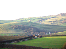
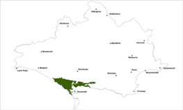
The Ridge and Vale landscape type is found to the east and west of Weymouth.
Key Characteristics
- broad evenly spaced ridges and valleys which follow a west-east alignment
- enclosed and defined by the dramatic chalk escarpment to the north
- mixed farmed area with a patchwork of geometric fields divided by straight hedges
- larger fields in the valleys and on the open ridges
- open views along the coast from the smooth, broad and hog-back shaped ridges
- distinctive settlement pattern along the valley floor and at the foot of the escarpment
- smaller scale and secluded landscape around Osmington
- the edges of the Weymouth conurbation create a negative impact on landscape character
The Ridge and Vale landscape type is enclosed to the north of the area by the imposing and dramatic chalk ridge/escarpment landscape type, which forms the setting and prominent backdrop to the area. This landscape is characterised by evenly divided low lying hog-backed limestone ridges running east to west, separated by undulating clay vales of mixed farming in a patchwork of medium sized geometric fields divided by straight hedgerows. There are larger scale fields on the open ridge tops and in the flatter valleys where there are also more hedgerow trees. Most of the woods are on the valley side slopes.
Management Objectives
The overall management objective for the Ridge and Vale Landscape Type should be to restore the characteristic features of grasslands and field boundaries along the coast, re-create and improve the urban fringe landscapes with new woodland planting, greenspace provision and reduce the impact of urban fringe.
Key land management guidance notes
- repair and maintain dry stonewalls along the coast and other important boundary features
- encourage grazing on the coast and inland limestone ridges to reduce further scrub encroachment
- manage permanent pastures including calcareous grassland and wet grasslands to protect wildlife and historic features
- prevent the loss of key landscape features and enhance archaeological features such as barrows through low impact grazing
- an integrated approach to increased informal access, nature conservation and ‘greenspace’ provision is needed especially because of the proximity of an urban population to important habitats
- where appropriate, encourage the planting of small-scale copses/woodlands to reduce visual impact of urban areas especially around the urban fringes
- identify, protect and conserve the sweeping views of the coast e.g. via parish action plans, village design statements and other settlement appraisals
- conserve and enhance the open character of coastal roads e.g. by the careful consideration of new development design, positioning and height
- encourage planting, habitat enhancement and other measures to reduce the visual impact of caravan parks where the open character is not affected. resist further expansion in open, sensitive locations
- conserve the pattern of tight knit nucleated villages
