Rolling wooded pasture


Location
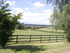
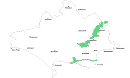
The Rolling Wooded Pasture landscape type is found around the margins of the Poole Basin and along the northern slopes of the Purbeck ridge.
Key Characteristics
- undulating, low and rolling hills with an irregular patchwork of pasture, woods and hedgerows
- small scale, intimate and enclosed mosaic landscape
- situated between the chalk and the heathland landscapes
- dense small woods of oak, ash and birch and hazel coppice
- mainly a pastoral landscape with some arable on flatter land
- many small villages linked by winding hedge lined lanes
- small patches of heath and/or unimproved grassland
- views limited by dense hedgerows and many small woods and copses
The Poole Basin is a low-lying area enclosed by the chalk to the north, west and south. The eroded dip slope fringes of the chalk are overlain by a mix of clays and poor acidic sands which produce the characteristic low rolling landform of this type with an irregular mosaic of hedgerows, woodland and pasture. There is therefore a gradual transition to chalk along the northwestern edges of this area. Across the type it is a small scale well wooded landscape of pastures, scattered trees and dense well treed hedgerows helping to shape and create a varied, intimate and rural landscape which contrasts with the more open broader scale of the chalk landscapes nearby. Remnant heathy patches are found in the Poole Basin areas where there is a gradual transition to less fertile agriculture associated with the heathland landscapes and small patches of unimproved grassland are found in the Purbeck hills area. This is often seen in the patches of regenerating wood in the corners of fields. It is a predominantly a pastoral landscape with larger arable fields on flatter land and there is a significant amount of common land compared with the rest of the county. The marginal farmland on urban edges is often the location for pony paddocks and its associated ‘clutter’. There are many small and picturesque villages, farms and hamlets scattered along the network of narrow and twisting hedge lined lanes. Many of the rural buildings and structures are traditionally constructed using local materials.
Management Objectives
The overall management objective for the Rolling Wooded Pasture Landscape Type should be to conserve its diverse intimate wooded pastoral character. Key features that unify the landscape must be conserved such as the woodland blocks, dense hedgerows and the presence of scattered trees. Enhancement of the many key features such as hedgerows, characteristic rural winding lanes and traditionally built structures and buildings is also required to conserve the sense of continuity across the landscape.
Key land management guidance notes
- restore important patches of heathland through phased conifer felling and introduction of grazing regimes
- conserve the ancient pattern of small irregular fields and narrow lanes interspersed with irregular patches of woodland
- enhance the management of permanent grassland to prevent loss to agricultural improvement and damage to wildlife and historic features
- encourage and promote grazing management
- maintain and conserve common land
- tree, woodland, hedgerow/hedgerow tree planting and hedgebank management noting that further conifer planting is not an objective
- link woodland blocks and hedgerows for example via land management initiatives and conserve the pattern of enclosed woodlands and open pastures
- enhance woodland management, particularly restoration of coppice, with small scale planting to connect existing woodlands and plant further scattered trees
- control and manage urban fringe uses such as ‘horsiculture’ to reduce their landscape and visual impacts e.g. through careful design & site planning, planning policy development and/or voluntary codes of practice
- identify, protect and conserve key public views e.g. via Parish Action Plans, Village Design Statements and other Settlement Appraisals
- promote recreational trails especially away from areas of ecological sensitivity through zoning, and relate to tourism and transport plans
- provide open space areas as physical barriers on edge of heathland areas as part of a wider Green Infrastructure initiative
- conserve parkland landscapes, associated features of interest and their setting especially those with no management plan
- promote/encourage the production of a comprehensive Landscape Design/Management Restoration Masterplan for Lulworth Camp
