Lowland heathland


Location
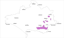
The undulating heathland landscapes of Dorset are found in the Poole Basin, a low-lying area enclosed by the chalk to the north, west and south.
Key Characteristics
- an undulating lowland landform with a distinctive open, exposed and uniform character
- associated with the poor, sandy and infertile soils of the Poole Basin
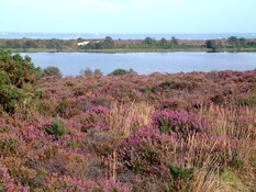
- a complex, diverse and often fragmented mosaic of heather carpets, grassland, birch/pine wood and scrub, which combine to create a blend of textures and colours
- heavily influenced by urban development and associated pressures
- wide, expansive and open views especially from elevated areas
- important European designated habitats and species
- a fragile landscape easily damaged by human activities e.g. fire and motorcycles
The acidic, light, sandy and impoverished soils on which this Lowland Heathland landscape type has evolved once supported extensive blankets of heath over much of the Basin. The transition from chalk to heathland landscapes follows the same consistent pattern across the Poole Basin. The lowland heathland landscape is a complex and diverse mosaic of open expansive dry and wet heath, acidic grassland, regenerating birch/pine wood and wooded scrubby heath which all combine to create a rich blend of textures and colours. Despite over 96% of Dorset's heathlands now being protected, a range of land uses affects condition, with the fragile and fragmented heaths under constant pressures, mainly due to their location adjacent to and within the southeast Dorset conurbation. Historically it was a remote unsettled terrain but modern development including significant conifer plantations, mineral extraction, planned farms, golf courses, roads and other urban fringe development has fragmented the remaining heathland patches. The roads are often straight, reflecting historic origins, and flanked by broad leaved woods. Much of the heaths are internationally important and designated wildlife habitats which contain many protected species such as Dartford Warbler and Sand Lizard. The wild and exposed appearance and feel of the open heathlands has been well documented in Thomas Hardy’s writings. There are numerous landmarks and distinctive open areas of heath such as Hartland Moor, Studland, Middlebere, Povington, Winfrith, Canford and Holt Heaths. Agglestone Rock, a dramatic isolated gritstone boulder, is a key local landmark near Studland and the transition to reed beds and marshes around Poole harbour is also a distinctive and important feature of the area.
Management Objectives
The overall management objective for the Lowland Heath Landscape Type should be to conserve and enhance existing heathland habitats and restore important former heathland sites. Enhance the balance of other heathland mosaics through improved management of scrub. Protect important conifer plantations that mitigate intrusive developments and provide for strategic recreation.
Key land management guidance notes
- restore important heathland habitats where they link up with existing heathlands and protect acid grasslands from further scrub encroachment
- tourism initiatives should be compatible with conserving Lowland Heathland, through zoning and developing appropriate transport infrastructure
- continue to support and fund The Urban Heaths Partnership
- restore mires back to functional ecosystems
- maintain the balance and protect heathland mosaics from scrub encroachment, bracken and woodland succession, particularly where these buffer existing heathlands, through promoting grazing regimes. Encourage woodland thinning within and around the wooded heath habitats.
- protect stands of mature broadleaved & conifer woodland along roadsides and create glimpses of open heathlands through scrub clearance
- conserve and enhance the existing open heathlands with continued support for extensive grazing regimes with protection of landscape trees and small woodland blocks.
- where woodland/scrub does not have a screening and biodiversity role, encourage phased removal
- soften edges of existing woodland blocks to follow landform and protection of important views.
- manage the impact of rising sea levels through creation of flood marsh around heaths adjacent to Poole harbour
- identify and protect important woodlands that screen intrusive development e.g. through planning documents and/or Parish Action Plans, Village Design, Statements and other Settlement Appraisals
- develop and implement a Green Infrastructure Strategy to include this key landscape type.
- protect open heathlands from excessive visitor pressure and associated infrastructure by careful planning of new development
- ensure mineral workings are mitigated as far as possible with clear aims for long-term restoration and enhancement
