Limestone plateau


Location
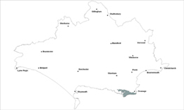
The Limestone Plateau landscape type is found in one location in Dorset and that is in south Purbeck.
Key Characteristics
- exposed sloping limestone plateau which plummets towards the sea along the cliff edge
- dramatic coastline with steep cliffs and incised deep valleys
- windswept wild landscape with virtually no trees
- defined by the long tradition of quarrying and use of local limestone, being covered by small quarries, spoil tips and tracks
- distinctive stark limestone villages and exposed farmsteads
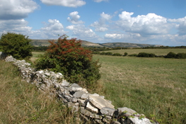
- mixed farming with geometric fields divided by walls and some weak hedges
- open expansive views across the Corfe valley to the sea and from the coast
- some important limestone grassland sites
The Limestone Plateau landscape has a simple but striking character represented by its windswept, exposed and treeless appearance. The elevated plateau slopes gently to the south, is gently rolling on the upper slopes and then drops dramatically to the sea. From the highest points of the plateau there are open views across the Corfe valley to the Purbeck chalk ridge and beyond to the sea. A long tradition of stone extraction has left its mark, shaping a near continuous network of stonewalls, extraction routes and small quarries dotted across the area and defining its character. This and the widespread use of the stone for building construction, creates a strong and visually unified character. The mixed farmed fields are mostly geometric in shape and enclosed by walls with some sparse hedges contributing to the areas stark appearance. Some scrub vegetation grows on the sheltered sides of walls and in the deep and narrow coastal valleys and clefts. These incised coastal valleys and steep cliffs are characteristic along the dramatic seaward edge of the area. There are some sweeping views along the coast from the South West Coast path where there are also some important open limestone grasslands which add biodiversity interest to the landscape. It is a well-settled landscape with isolated farms and Langton Matravers and Worth Matravers being distinctive limestone villages and the main settlements on the plateau. The north-south aligned side lanes are generally straight, joining up with the main ridgetop road at right angles. The hard southern edges of Swanage detract from the character of the area and signs, telegraph poles and spoil heaps are all prominent on the skyline in this open landscape and therefore also detract from local character. Priest’s Way is an ancient track and right of way running across and linking the plateau, forming a key feature.
Management Objectives
The overall management objective for the Limestone Plateau Landscape Type should be to conserve the strong open character, restore the important limestone grasslands and stone field boundaries across the plateau and ensure new built development respects, conserves and where possible enhances local character.
Key land management guidance notes
- repair and maintain dry stonewalls and replace post and wire fences with walls where possible.
- protect historic field patterns and features.
- encourage grazing to manage scrub encroachment on grasslands and encourage reversion of arable to grassland where appropriate.
- enhance management of permanent pastures including limestone grasslands around historic features.
- woodland planting is not an objective for the area.
- conserve the strong patterns of village forms and use of local stone in new built and restoration work
- reduce the impact of urban edges, car parks and other visitor based development e.g. through sensitive signage and improved management of built features such as walls
- conserve and enhance the open character of coastal roads e.g. by the careful consideration of new development design, positioning and height.
- identify, protect and conserve the sweeping views of the coast e.g. via Parish Action Plans, Village Design Statements and other Settlement Appraisals.
- ensure quarry restoration plans helps to enhance the ecological and cultural value of the landscape.
- reduce intrusive urban fringe development e.g. by the careful consideration of caravan parks and other associated development especially around Swanage.
