Wooded chalk downland


Location
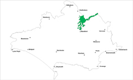
The Wooded Chalk Downland landscape type is found in one location in Dorset, in the Cranborne Chase, between the chalk escarpment and the open chalk downland of east Dorset extending east into Wiltshire.
Key Characteristics
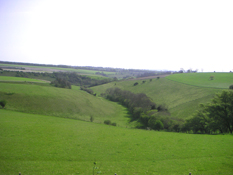
- exposed and elevated landscape with dramatic intersecting dry coombe valleys and rounded upstanding ridges.
- well wooded with mixed woods, shelterbelts, copses and clumps creating a series of ‘enclosed spaces’ surrounded by trees.
- a mosaic of downland, improved grassland and arable fields between the woods.
- ancient woodland and chalk grassland habitats are key wildlife conservation sites.
- few settlements and scattered farmsteads.
- use of locally distinctive building styles and materials creates a strong vernacular tradition.
- panoramic views over adjacent escarpments and foothills.
- medieval royal hunting grounds with surviving features such as park pales.
- many important archaeological sites such as burial mounds, cross dykes and earthworks.
- Pushmore Park estate is a distinctive ‘historic planned landscape’ feature.
The Wooded Chalk Downland type is a dramatic, distinctive and historic landscape with a characteristic deeply eroded topography of steep chalk valleys, dry coombs, upstanding ridges and plateaus with open views. This rolling landform together with the distinctive land cover mosaic of improved grassland, shelter belts, ancient woodland and open downland creates its unique sense of place with the landcover creating ‘enclosed spaces’ surrounded by trees. Most of the area was ancient royal hunting ground and has a greater percentage covering of woodland and veteran trees than the adjacent chalk downland areas. Clipped hedgerows provide field boundaries to mostly medium to large irregularly shaped fields and to the generally straight roads and lanes which run across the area. The area has been settled continuously from the Iron Age, with evidence of many prehistoric earthworks, but now there are few settlements with Ashmore being the only hilltop village in the area. The rest of the buildings, hamlets, farms and old lodges are disbursed throughout the area and are often linked via a dense network of bridleways and footpaths. The buildings across the area often use locally distinctive construction materials such as redbrick, flint, white render (cob) and slate. It is a remote part of the county and therefore has a tranquil and undeveloped feel. The extensive ancient woodlands of Ashmore and Chase Woods and the managed estate landscape of Rushmore Park are all key features in the area.
Management Objectives
The overall management objective for the Wooded Chalk Downland Landscape Type should be to conserve the distinctive classical English landscape created by the dramatic chalk valleys, ridges and plateau, diverse woodland, copses, shelterbelts, avenues and parkland trees. In particular there is a need to re-invigorate woodland management within this area.
Key land management guidance notes
- maintain a balance of coppice woodlands with high forest stand types relating to character of existing woodlands and newly created ones. Natural regeneration should be encouraged wherever possible bearing in mind the influence of an increasing wild deer population.
- improve recreational links into the countryside.
- ensure woodland management objectives are compatible with the landscape and that all age classes of native trees are adequately represented to ensure continuity
- restoration of hedgerows where ‘gappy’ and fragmented and repair or replacement of estate boundaries where in decline.
- encourage natural regeneration and planting of native species to restore deciduous character and ecological diversity of re-planted woodlands. Beech may also be an appropriate species in this area, particularly planted as hedgerows and clumps.
- conserve the parkland character by promoting a programme of tree planting to replace individual and parkland trees as they become over-mature and die.
- encourage traditional management techniques and marketing of local wood products to restore the character of coppice woodland and wood pasture.
- recognize the importance of non-intervention woodlands as an element of the wooded landscape which may be biologically rich, supporting several key species, e.g. woodland birds requiring old growth trees
- consider opportunities for reversion from arable to chalk grassland on hills and bluffs where highly visible.
- conserve integrity of archaeological features such as burial mounds, wood-banks, field systems and park pales and promote cultural value perhaps through interpretation for visitors.
- promote sustainable management of recreation particularly in relation to the proposed Open Country designation.
- identify, protect and conserve the long ranging views especially from roads, Rights of Way and key viewpoints e.g. via Parish Action Plans, Village Design Statements and other Settlement Appraisals.
- conserve the distinctive character of the landscape and the long ranging views especially from roads, Rights of Way and key viewpoints e.g. by keeping built development off the ridge tops and exposed downland summits.
- veteran trees should be identified and conserved e.g. using a planning checklist.
