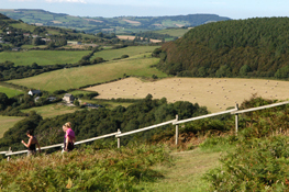
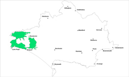
Wooded hills


Location
The Wooded Hills landscape type is found over a significant part of the western end of Dorset.
Key Characteristics
- very varied and undulating pastoral farmland scenery with broad rolling hills, steep greensand ridges, some steep incised valleys and a dramatic coastline.
- wooded valley side slopes interspersed within a patchwork of fields and hedges which become more irregular and smaller scale on steeper land.
- distinctive steep greensand summits with heathland vegetation cover.
- many of the summits are key local landmarks.
- distinctive and popular coastal landscape of headlands, eroding cliffs and undercliffs, landslips and small beaches.
- narrow twisting hedge lined lanes.
- many scattered farmsteads and small villages.
The variable, undulating farmland scenery of the Wooded Hills landscape continues over the border into Devon and Somerset and has a diverse structure from steep greensand ridges, incised valleys, broad rolling hills and distinctive conical shaped hills. Several clusters of these conical shaped hills are found around and define the Marshwood and Powerstock Vales and help create an enclosed and intimate landscape. Pilsden Pen is part of the curved ridge which divides the Marshwood Vale from the hills to the north. Typically the woodland is found on the valley sides with a network of dense hedgerows, winding lanes and small clustered settlements dotted throughout this predominantly pastoral landscape. The patchwork of fields, dense hedges and woods becomes more irregular and smaller on the steeper land where the pattern is broken on the greensand summits by a mosaic of heathland vegetation. There some elevated mainly greensand ridges/hills such as Pilsden Pen, Leweston Hill, Langdon Hill, Lamberts Castle, Conegar Hill and Golden Cap which all form key landmarks across the area. The popular, dramatic and varied coastline has a number of key features such as the South West Coast Path, the tumbling landslips around Lyme Regis and Charmouth as well as the prominent headlands of Golden Cap and Thorncombe Beacon. Seaton is a picturesque coastal village in a small valley between the headlands. There are several visually prominent campsites along this coastline which impact on landscape character. The market and coastal towns and villages in and around the area such as Powerstock, Symondsbury, Marshwood, Broadwindsor and Wotton Fitzpaine support a long tradition of artistic interpretation of the landscape and local cultural traditions. The villages and scattered farmsteads are found along the dense network of narrow lanes which often have steep hedgebanks.
Management Objectives
The overall management objective for the Wooded Hills Landscape Type should be to conserve the intimate, undeveloped and pastoral appearance and protect the wooded character. Ongoing protection of hedgerows, rural lanes, small scale pastures, open skylines and settlement character are also important considerations.
Key land management guidance notes
- conserve the ancient pattern of small irregular piecemeal enclosures, assarts and strip fields.
- protect the wooded character and enhance woodland management with small scale planting of broadleaves along valley sides. Protect the character of important open skylines from future planting.
- protect the character of elevated woodlands on key ridges.
- buffer woodland edges with graded scrub to enhance biodiversity and ameliorate wind buffering to exposed woodland.
- protect wet flushes and spring lines where these appear.
- conserve and enhance permanent grassland and prevent loss to agricultural improvement and damage to wildlife and archaeological features. Promote low impact grassland management.
- conserve existing orchards and promote new establishment.
- encourage maintenance of species rich hedgerows and trees, particularly along the valley floors and replant any gaps where necessary. Resist use of post and wire.
- manage the retreat of coastal landscapes and associated coastal corridor and manage the coastal corridor to minimise erosion pressures.
- restore important patches of heathland through phased conifer felling and introduce grazing regimes.
- prevent further expansion of caravan parks in sensitive locations and promote enhanced management of existing sites to help integrate them and enhance their appearance.
- maintain undeveloped character and resist intrusive developments on sensitive hillside locations.
- consider screening views of intrusive agricultural buildings and/or settlement edges through planting new small-scale native broadleaved copses/woodlands.
- conserve the ancient pattern of small irregular piecemeal enclosures, assarts and strip fields e.g. by the careful consideration of new development design and positioning.
- protect patterns of strip lynchets and their landscape setting e.g. by the careful consideration of new development design and positioning.
