Valley pasture


Location
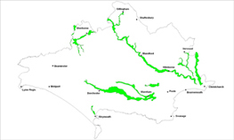
The valley pasture landscape type is found along the Stour, Frome, Piddle, Moors, Sherford, Avon and Yeo river systems based on alluvial soil deposits.
Key Characteristics
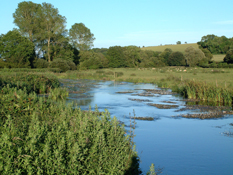
- flat and open valley floor landscape with distinctively meandering river channels which often floods.
- typically a grazed pastoral landscape based on deep alluvial and gravel soils.
- generally large fields with a mosaic of smaller fields abutting the river edges.
- groups of riverside trees follow the watercourses creating key features along the valleys.
- old water meadow systems and features are common.
- settlements and transport corridors follow the valley floor.
- historic river crossings points are often over old bridges.
- the valleys provide the historic and cultural setting to many county towns.
- widens out towards the coast and merges with the harbour side landscapes at Poole and Christchurch.
The rivers are the key context for this landscape type, which have flat, wide meandering floodplains that historically support transport routes and major development around the fringes of the areas. There are large open fields with a mosaic of smaller fields and copses along the river edges which are all prone to flooding. These groups of riverside trees and woodland form key landscape features. The area is a predominantly pastoral grazed landscape with some arable towards the river terraces. A series of wet ditches and small channels, wet woodlands, small pastures and old water meadows are typical of this landscape type as are the presence of old bridges and causeways. The lower reaches merge with extensive areas of pasture, reed bed and marsh associated with the Harbour/wetland/lagoon landscape type. The valley floors are the focus for settlements, transport and infrastructure corridors and historic river crossings. The later being the historic focus for settlements such as Wool and Sturminster Marshall. Settlements such as Dorchester, Wareham, Burton, West Stafford, Moreton, Spetisbury and Shapwick are often on the slightly elevated low terraces to the side of the valleys. The area is also where sand and gravel extraction has and still is taking place, creating its own set of impacts.
Management Objectives
The overall management objective for the Valley Pasture Landscape Type should be to conserve the strong visual unity of the valley, the diversity of semi-natural habitats and to restore features such as wet woodlands pastures, water meadows, boundary features and historical lanes and bridges. Opportunities for large-scale multi functional landscape restoration and creation should be promoted and explored particularly in the Stour Valley.
Key land management guidance notes
- encourage opportunities for reversion from arable cropping back to pasture on the valley edges, linking up areas in good condition and enhancing the management of existing wet pastures and river edge fields.
- encourage maintenance of boundaries, particularly parkland railings and walls along the valley floors.
- identify, conserve and restore remnant water meadow systems that are important historic landscape features.
- consider planting a new generation of native floodplain trees to replace those that are becoming over-mature and to replace elms that were lost during the twentieth century.
- consider extending wet woodland on the valley floor, particularly around existing settlements.
- restore water meadows for additional flood storage in the valleys.
- promote grazing and hay meadow management initiatives and projects.
- create, maintain and manage low intensity ‘open space edges’ to the immediate river corridor (e.g. fencing sections of waterbodies, to allow natural regeneration of trees and associated scrub/carr).
- encourage and promote tree, woodland, hedgerow/bank management and in particular veteran trees such as old pollards and boundaries particularly along the valley floors.
- promote and contribute to River Corridor Management projects.
- improve and maintain access/path network to the river corridor for example via land management initiatives.
- seek to provide multi functional ‘Green Open Space’ opportunities which can serve as a recreational links from main urban centres into the surrounding countryside along the valleys.
- seek to restore traditional mills, bridges, causeways and farmsteads of local stone and other traditional materials.
- use a landscape character based approach to consider the most appropriate location for future sand/gravel quarrying e.g. trying to avoid open, exposed and visually sensitive locations.
- consider how restored quarry sites can contribute to a coordinated approach to open space provision within the valleys.
- strengthen the character of the landscape where it has been eroded by urban developments e.g. by linking existing ribbons of trees with complimentary new native planting.
