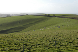
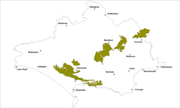
Open chalk downland


Location
The Open Chalk Upland landscape type is found around Dorchester, to the south and east of Blandford and follows the chalk escarpment to the south and east of Dorchester, into the Isle of Purbeck.
Key Characteristics
- elevated areas of open chalk upland with a broad rolling landform
- gentle curving convex profiles to the landform
- an expansive open scale with panoramic views to distant landmarks
- uniform and homogenous landscape character
- patchwork of large-scale arable fields subdivided by low, straight and weak hedges
- isolated small blocks of geometrically shaped woods
- sparsely populated with few settlements and scattered isolated farmsteads
- a network of widely spaced roads, footpaths and bridleways
- many important archaeological sites such as long barrows and burial mounds
- literacy associations with Thomas Hardy
The Open Chalk Upland landscape merges seamlessly into the adjacent Chalk Valley and Downland areas and is simple, large-scale expansive landscapes of broad rolling open hills with large agricultural estates mainly under arable production. Partly circled south of Dorchester by a narrow face of steep escarpments, the open uplands provide the setting for a series of intimate chalk river valleys in this part of the county. The curving convex profiles to the land form help provide wide and open vistas providing panoramic views to distant landmarks. The land cover is a patchwork of large arable fields bounded by straight and low hedges or fencing with isolated small blocks of geometrically shaped woodland. Numerous ancient settlement sites, long barrows and burial mounds from the Neolithic and Bronze ages dot the landscape to indicate a historically well-settled landscape. However it is now a relatively sparsely populated area with a network of widely spaced out straight lanes, roads and other public rights of way. Some of the roads follow old Roman routes and there are only scattered isolated farmsteads across the area. The most notable literary associations of the area come from that of Thomas Hardy’s writings of culture, history and landscape. The atmosphere and natural forces of the chalk uplands are clearly evident throughout his works with description of traditional land management practices. Hardy’s Monument, the commemorative tower on Black Down hill and the Iron Age hill forts at Maiden Castle and Badbury Rings are all prominent and key landmarks in the area.
Management Objectives
The overall management objective for this Open Chalk Upland Landscape Type should be to conserve the distinct downland landscape of broad rolling hills and gentle slopes whilst restoring the condition of many of its characteristic features to increase visual unity and make the combination and pattern of elements more distinct.
Key land management guidance notes
- restore and extend native habitats of chalk grassland, ancient broad leaved oak woodland, and calcareous meadows. for grasslands, encourage opportunities for reversion from arable cropping back to chalk grassland on the valley sides, linking up areas in good condition and enhance management of existing chalk grasslands
- restore and conserve chalk streams and other watercourses along with associated habitats and features of cultural interest
- conserve and enhance the integrity and setting of archaeological features through low impact grassland management and promote wider understanding through selective and sensitive interpretation for visitors
- restore important boundary features of cultural interest where the open character of the downs will not be affected
- promote the natural regeneration and planting of small oak, ash and hazel broadleaved woodlands on gentle slopes to increase landscape diversity. new coniferous planting and shelterbelts should not be encouraged
- restore and enhance old hazel coppice stands
- conserve the distinctive open character of the landscape e.g. by keeping built development off the ridge tops and exposed downland summits
- identify, protect and conserve the long ranging views especially from roads, rights of way and key viewpoints e.g. via Parish Action Plans, Village Design Statements and other Settlement Appraisals
- improve recreational links into the countryside to tie in with the provision of functional ‘greenspace’ where possible around settlements
